

Latest Weather Blog
Sunday PM Forecast: Awaiting a push of drier, more comfortable air
After a very hot weekend, the Storm Station is tracking a "cool" front which will deliver relief from the summer steam.
Tonight & Tomorrow: The weather will remain quiet on Sunday evening across south Louisiana. Storms will be ongoing in Arkansas and northern Louisiana, traveling in a southward direction. Most data seem to suggest that the storms dissipate upon arrival in the capital area. However, the scenario has played out several times in the past where a wave of storms passes through, even when computer models suggest the contrary. For that reason, a few late night storms are still on the table - but know that rain is by no means a guarantee. Any storms that can survive will be capable of gusty winds. The night will otherwise be warm and sticky with a low close to 80°.
A cool front will be approaching from the north on Monday. Although the front gets close, it doesn't pass. This leaves southeast Louisiana in the sultry air for another afternoon. Look for a high temperature in the mid-90s with the same humid feel from recent days. The primary heat relief on Monday will be in the form of cooling showers. This rain will push into the region from a separate wave of storms forming near the Ozarks a few hours before dawn. These showers could pass through the Baton Rouge area sometime between the morning and early afternoon hours on a widely scattered basis. One or two cells could be capable of gusty winds and perhaps some embedded hail.
Up Next: The front mentioned above will finally push through the region on Monday night. The front will hardly affect afternoon highs which will remain in the upper-90s. However, overnight lows drop closer to average - in the low-70s. The main impact of the "cool" front will be a drop in humidity which most will begin to feel on Tuesday. So although daytime highs don't budge, it will still feel cooler due to significantly lower feels-like temperatures. The humidity remains low through Thursday. Afterward, the summer stream gradually makes a comeback.
The Tropics: Ernesto strengthened back into a hurricane once more on Sunday afternoon as the system continues northeast into the North Atlantic. Ernesto may maintain hurricane status for another day before weakening to a tropical storm on Tuesday. By midweek, Ernesto will likely be a strong post-tropical system accelerating eastward into cooler waters.
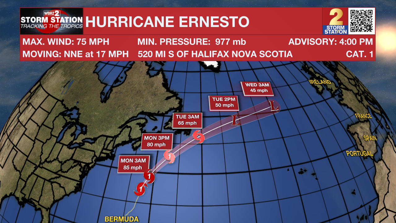
There are no other areas of concern in the Atlantic Basin at this time.
Trending News
Get the latest 7-day forecast and real time weather updates HERE.
Watch live news HERE.
-- Meteorologist Malcolm Byron
The Storm Station is here for you, on every platform. Your weather updates can be found on News 2, wbrz.com, and the WBRZ WX App on your Apple or Android device. Follow WBRZ Weather on Facebook and Twitter for even more weather updates while you are on the go.
More News
