

Latest Weather Blog
Sunday AM Forecast: trading the heat for the rain the next several days
We are finally done with the upper 90's for the foreseeable future. In its place, will be a very wet pattern the next several days.
Today & Tonight: Today has started off mainly clear for most areas, but showers have already begin to move in from the Gulf of Mexico. These will continue to advance inland, and increase in coverage as we go throughout the day. Here in the capital area, rain chances should really begin to increase by 12-1 pm. Our best chance of rain will be in the afternoon and evening hours. This is where we are expecting scattered showers and thunderstorms across the area. Overall, the best chance of rain, and greatest rain totals will be in coastal areas. Even further inland, there will be the chance of heavy rain causing some isolated flash flooding issues. This will be especially true in typical poor drainage areas. Highs today will make their way to 93 degrees. Increasing cloud cover, and rain moving in will keep that temperature from rising any further.
While there are some indications of us drying out in the overnight hours, I would not 100% count on that. There will still be plenty of moisture around, so isolated to scattered showers and storms cannot be ruled out. Lows will be near 76 degrees.
Up Next: This upcoming week will continue to be unsettled. Monday will likely be the wettest day, followed by Tuesday. Excessive rainfall will be possible during that period. Rain coverage will back off slightly Wednesday, before we begin to dry out a bit by the end of the week. Some slight chances of rain will still remain possible. In total, most areas will receive 1-3 inches of rain, with locally higher totals Sunday through Wednesday. Temperature wise, the beginning of the week will have highs in the mid 80's because of all the rainfall. After that point, highs will begin to rebound back to the lower 90's by Thursday.
Trending News
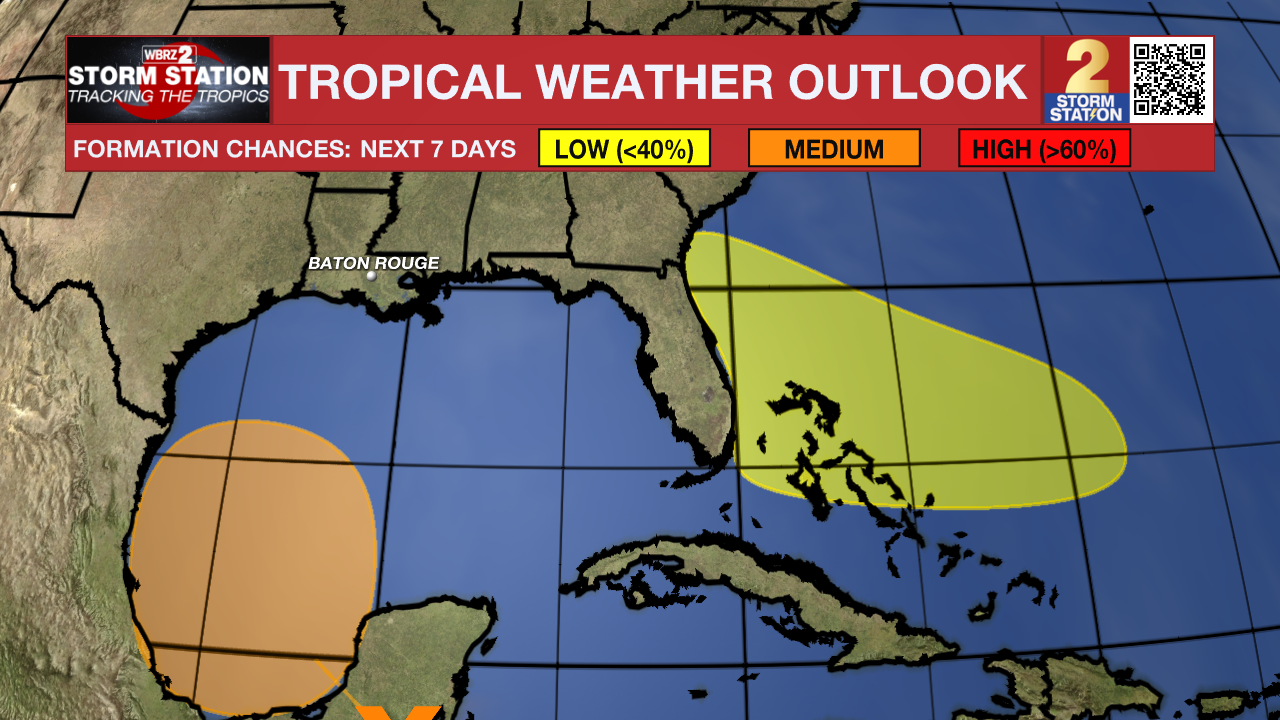
The Tropics: A large area of disturbed weather has formed over Central America, the Yucatan Peninsula of Mexico, and the adjacent waters of the northwestern Caribbean Sea. A broad area of low pressure is forecast to form from this system over the southwestern Gulf of Mexico in a day or two. Environmental conditions appear conducive for gradual development of this system, and a tropical depression could form by midweek while it moves slowly westward or west-northwestward. This system will not affect our forecast, regardless of development.
An area of low pressure is forecast to form by midweek a few hundred miles northeast of the central Bahamas. Environmental conditions could be conducive for some development of this system thereafter while it moves westward or west-northwestward. While this system is no immediate cause for concern, it is just something to watch the next several days.
Get the latest 7-day forecast and real time weather updates HERE.
Watch live news HERE.
– Balin
The Storm Station is here for you, on every platform. Your weather updates can be found on News 2, wbrz.com, and the WBRZ WX App on your Apple or Android device. Follow WBRZ Weather on Facebook and Twitter for even more weather updates while you are on the go.
More News
