

Latest Weather Blog
Saturday PM Forecast: Heat Dome is here to stay until mid next week
To conclude the weekend, expect very similar conditions to today. Temperatures will soar to the upper 90s, with humidity making the feels-like temperature near 105 degrees. The hot pattern will start to shift somewhat by the middle of next week.
Tonight & Tomorrow: Not a shower in sight as we approach tonight. Mostly clear skies will be in the viewing area as we go into the new day, with the low temperature reaching near 74°.
Sunday will be similar to today, with mostly sunny skies as we wake up, and the heat dome still in effect. The high temperature will be near the upper 90s. Also, with the humidity in play, the feels-like temperature will be near 105 degrees, almost reaching the heat advisory criteria. Because of peak daytime heating, you can expect some spotty showers. The vast majority will stay dry. The Storm Station advises to stay hydrated during this weekend’s hot weather stretch and take it easy during the peak heating hours.
Up Next: The weather over the weekend will spill into Monday, where it will be another hot and humid day. Temperature will soar to the upper 90s with the heat dome still in play. Once again, some spotty showers/storms cannot be ruled out. As we approach midweek, indications start to show the heat dome breaking down, allowing the hot and dry weather to break somewhat. Temperatures will slightly back down to the mid and lower 90s with moisture and rain chances returning. This will be some much needed relief after the very hot stretch.
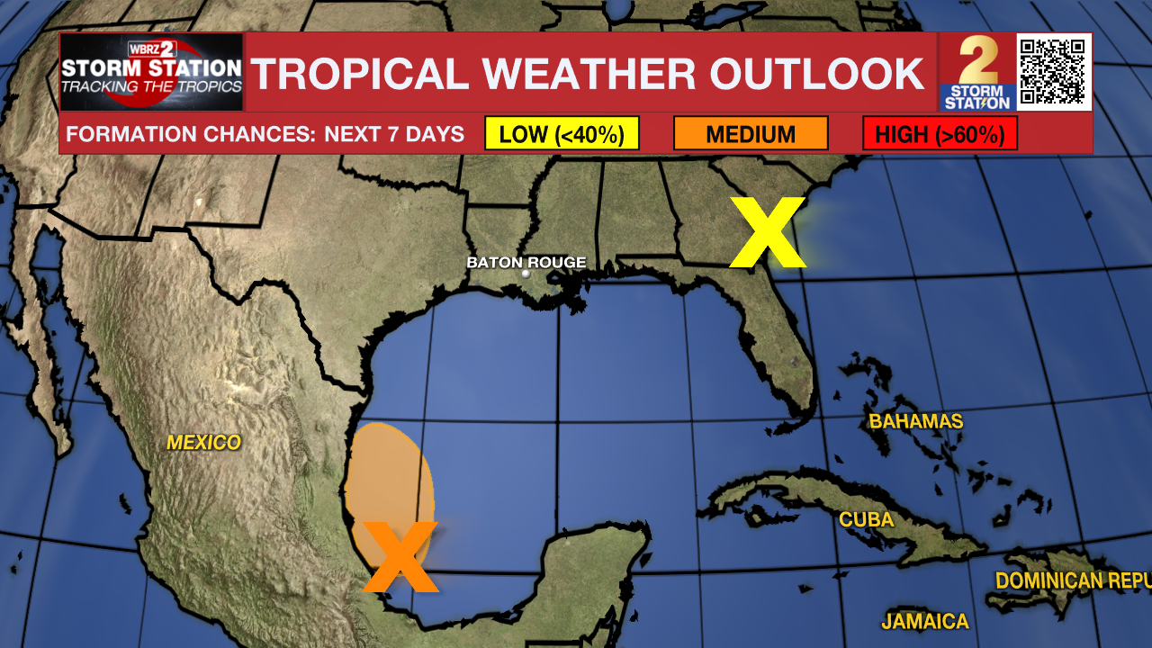
The Tropics: A broad low pressure system located over the southwestern Gulf of Mexico is producing a large area of disorganized showers and thunderstorms. Environmental conditions appear conducive for gradual development of this system as it moves slowly west-northwestward or northwestward, and a tropical depression could form before the system reaches the coast of northeastern Mexico Sunday night. Regardless of development, heavy rainfall could cause localized flooding across portions of northeastern Mexico and Deep South Texas through the end of the weekend. An Air Force Reserve reconnaissance aircraft is scheduled to investigate this system later today, if necessary.
A low pressure system centered inland over southeastern Georgia is producing disorganized showers and thunderstorms, mainly over the coastal waters off of northeastern Florida and Georgia. The low is expected to drift slowly northwestward or northward today before dissipating tonight. Tropical cyclone formation is not expected.
Trending News
Get the latest 7-day forecast and real time weather updates HERE.
Watch live news HERE.
-- Balin
The Storm Station is here for you, on every platform. Your weather updates can be found on News 2, wbrz.com, and the WBRZ WX App on your Apple or Android device. Follow WBRZ Weather on Facebook and Twitter for even more weather updates while you are on the go.
More News
