

Latest Weather Blog
Saturday AM Forecast: Plenty of sunshine but still cold
Be sure you are bundling up for these next few days.
THE FORECAST
Today & Tonight: HARD FREEZE WARNING will continue across the WBRZ viewing area until Sunday morning. The WIND CHILL ADVISORY is still in effect until 10am Saturday. Waking up this morning, winds are still 10-15 mph out of the north and temperatures are in the low-20s. The sun will be around all day long, but temperatures will still struggle. Daytime highs will get just above freezing in the mid-30s, but winds will remain breezy out of the north leaving us feeling colder than it actually is. Overnight temperatures will fall back before freezing quickly heading into Christmas.
Up Next: A cold Christmas morning ahead. Waking up the skies will be clear and temperatures will be in the low-20s. The hard freeze warning will expire Sunday morning as temperatures start to climb into the low-40s throughout the afternoon. It will still be windy but the cooler weather will be more manageable. There will be plenty of sunshine around for your Christmas day. I would still bundle up, especially if you have outdoor plans. Overnight we will start to see temperatures falling above freezing in the mid-30s. Into the workweek temperatures will gradually rise. Monday will be dry and just a little bit warmer. By the end of the week temperatures will be back into the 70s. Our next chance for rain moves back into the forecast later in the week. Click here to see the 7-day forecast.
Be sure you stay connected ahead of the frigid conditions. The Storm Station has you covered with hour-by-hour weather tracking is available for your location on the WBRZ WX App on your Apple or Android device. Follow WBRZ Weather on Facebook and Twitter for even more weather updates and unique weather insight from the whole team!
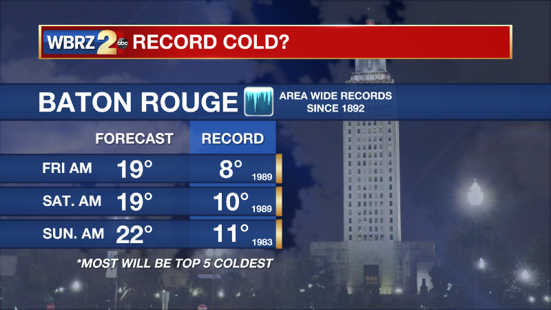
(((Following Data courtesy of National Weather Service)))
Trending News
Every event is different and should be treated as such, but for some modern reference, here are a few relatable cold outbreaks:
-February 2nd through 5th 1996
-January 8th through 11th 2010
-February 15th through 17th 2021.
This cold blast will likely be more potent than the 2021 event. However, IT WILL NOT be accompanied by significant wintry precipitation thereby eliminating the risk for ice induced power outages.
As for a reference to Christmas, surprisingly there are two relatable historic events:
-December 23rd through 26th 1983
-December 22nd through 25th 1989
These two were extreme events and at this time we are not expecting to test those records. The 1989 cold airmass still holds numerous records across a good portion of the United States including locally where single digits were recorded in many places. We would have to go back to 1899 to see temperatures recorded lower than 1989 in much of the area over a multi day stretch.
More News
