

Latest Weather Blog
Saturday AM Forecast: highs way above average, fog possible in the mornings
Highs will stay unseasonably warm this weekend with some records being threatened. In the mornings, it will be comfortable, with fog around the area.
The Weekend: Sunshine will dominate the skies this weekend. A few clouds might be noticed on Sunday, but these will be the high cloud variety. Temperature wise, both days will feature highs close to 90 degrees. The record high for Saturday is 90 degrees, set in 1939 and 1921. The record high for Sunday is out of reach at 95 degrees. Sunday morning will be comfortable with a low near 62 degrees. Fog will once again be a possibility.
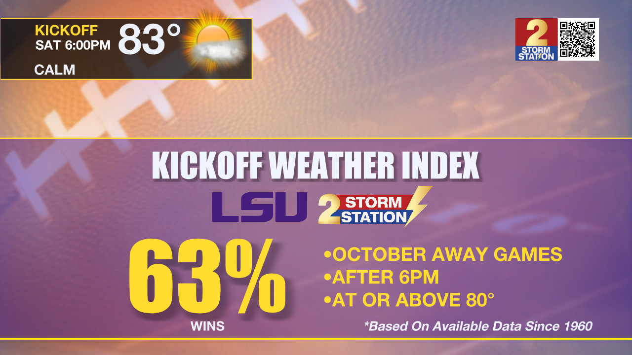
Away Football Games: Both Capital Area teams will be hitting the road this weekend for two highly anticipated match-ups. As LSU takes on Texas A&M Saturday night in College Station, fans should expect warm tailgating conditions that afternoon with temperatures in the upper 80s under mainly sunny skies. According to the LSU Kickoff Weather Index, this will be the latest game into the calendar year that LSU has played on the road at night with a kickoff temperature above 80 degrees. Similar conditions are expected in Tallahassee, FL as Southern takes on Florida A&M. The evening kickoff will be mild after a warm afternoon full of sunshine and highs in the mid 80s. Thermometers will end up in the 70s by the end of the game. Fans heading to Florida or Texas this weekend will not need to pack any raingear but don't forget the sunglasses!
Up Next: A cold front will be moving into the Lower Midwest early next week. This front will not have the support needed to pass the local area. It will get close enough to allow winds to increase across the Capital Area. This will limit fog potential, and also lead to an increase in moisture. At first, this moisture will support some low cumulus cloud development early in the week. As the moisture gets deeper, skies will turn mostly cloudy later in the week with showers even becoming possible Wednesday through Saturday. The best day for rain as of now looks to be Thursday. On Monday and Tuesday highs will be in the upper 80s with lows in the low 60s. The temperature range will shrink later in the week due to the added moisture and clouds with highs in the mid 80s and lows in the mid 60s.
Trending News
Get the latest 7-day forecast and real time weather updates HERE.
Watch live news HERE.
The Tropics: After a long active period, the Gulf of Mexico, Caribbean Sea and Atlantic Ocean are quiet. No tropical development is expected over the next seven days.
– Balin
The Storm Station is here for you, on every platform. Your weather updates can be found on News 2, wbrz.com, and the WBRZ WX App on your Apple or Android device. Follow WBRZ Weather on Facebook and Twitter for even more weather updates while you are on the go.
More News
