

Latest Weather Blog
Saturday AM Forecast: get the ice and cooler ready, hot weekend ahead
The weather theme for this weekend is hot! Plentiful sunshine both Saturday and Sunday will drive highs into the upper 90's.
Today & Tonight: Today is shaping up to be a hot day. Mostly sunny skies will allow temperatures to reach near 98 degrees. This is one degree shy of the record. Humidity will make the feels like temperature near 105 degrees. The UV index will be in the very high category at 11. This means sunburns will happen very quickly. If outside, make sure you are drinking plenty of water, and wearing sunscreen. Tonight, lows will be near 75 degrees under mostly clear skies.
Up Next: Temperatures will be similar on Sunday, but humidity will increase even further. This will push feels-like temperatures closer to 110° in some spots. Should this occur, this would surpass the threshold to warrant a Heat Advisory (feels-like 108°+). As of now, the advisory has yet to be issued, but the Storm Station still advises that everyone stay plenty hydrated and take it easy during the peaking heating hours this weekend - alert or not. Monday will be another scorcher, but indications point toward the heat scaling back by midweek. This will also coincide with the return of moisture and higher rain chances to the capital area
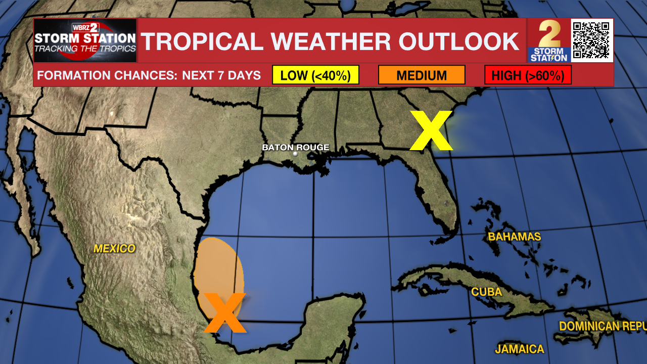
The Tropics: A broad low pressure system located over the southwestern Gulf of Mexico is producing a large area of disorganized showers and thunderstorms. Environmental conditions appear conducive for gradual development of this system as it moves slowly west-northwestward or northwestward, and a tropical depression could form before the system reaches the coast of northeastern Mexico Sunday night. Regardless of development, heavy rainfall could
cause localized flooding across portions of northeastern Mexico and Deep South Texas through the end of the weekend. An Air Force Reserve reconnaissance aircraft is scheduled to investigate this system later today, if necessary.
A low pressure system centered inland over southeastern Georgia is producing disorganized showers and thunderstorms, mainly over the coastal waters off of northeastern Florida and Georgia. The low is expected to drift slowly northwestward or northward today before dissipating tonight. Tropical cyclone formation is not expected.
Trending News
Get the latest 7-day forecast and real time weather updates HERE.
Watch live news HERE.
-- Balin
The Storm Station is here for you, on every platform. Your weather updates can be found on News 2, wbrz.com, and the WBRZ WX App on your Apple or Android device. Follow WBRZ Weather on Facebook and Twitter for even more weather updates while you are on the go.
More News
