

Latest Weather Blog
NEW: Severe T-Storm Watch issued ahead of Monday evening storms
UPDATE (5/13/24, 7:16PM)
NEW TORNADO WARNING for Ascension, East Baton Rouge, Iberville, & Livingston
-----------------------
UPDATE (5/13/24, 7:01PM)
SEVERE THUNDERSTORM WARNING issued due to possible winds of 80 miles per hour. Take shelter NOW in a sturdy building. Parishes affected: . East Baton Rouge, East Feliciana, Iberville, Pointe Coupee, West Baton Rouge LA, & West Feliciana
----------------
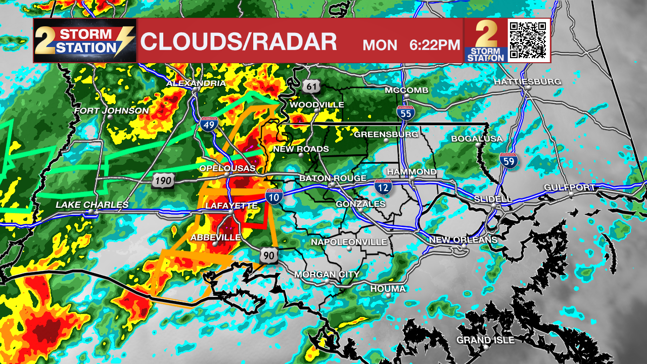
UPDATE (5/13/24, 6:21PM) -- a line of severe thunderstorms was barreling toward the Capital Area at 55-65mph. These storms have had a history of damaging wind gusts, some hail and even a likely tornado in Lake Charles. Action is expected to arrive in the Metro Area around 7pm. Be prepared for all of the hazards previously mentioned. If a warning is issued for your area, seek shelter in a low level, interior space away from windows. Put as many walls between yourself and the outside as possible.
Trending News
The National Weather Service has issued a SEVERE T-STORM WATCH for the entire WBRZ coverage area until 12 a.m. Tuesday.
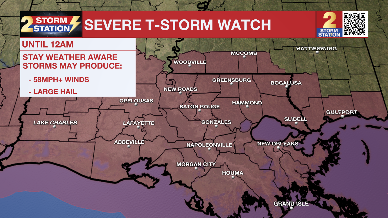
A SEVERE T-STORM WATCH means that conditions are favorable for damaging winds and/or large hail. Isolated tornadoes also cannot be ruled out. Be on the lookout for threatening weather conditions and listen for later statements as possible warnings. If a Severe T-Storm Warning is issued, shelter in a sturdy, enclosed building. Avoid covered decks, large rooms, and shed if possible. Also be sure to get animals to shelter until the storm passes For more on severe thunderstorm safety, CLICK HERE.
The latest radar trends suggest a potent round of storms will move across southern Louisiana as the evening wears on.
535p Monday: A strong line of storms prompting several Severe T-Storm and Tornado Warnings through the afternoon continues east.
— Malcolm Byron (@mbyronwx) May 13, 2024
Severe weather odds are increasing for the capital area as nightfall approaches... #LAwx pic.twitter.com/IJP2YyD9Rx
A ***FLOOD WATCH*** is in effect along the I-10/12 corridor through 6 a.m. Tuesday. This is a new update - Pointe Coupee, West Feliciana, East Feliciana, St. Helena, Northern Tangipahoa Parishes along with Wilkinson and Amite Counties were removed on Monday afternoon.
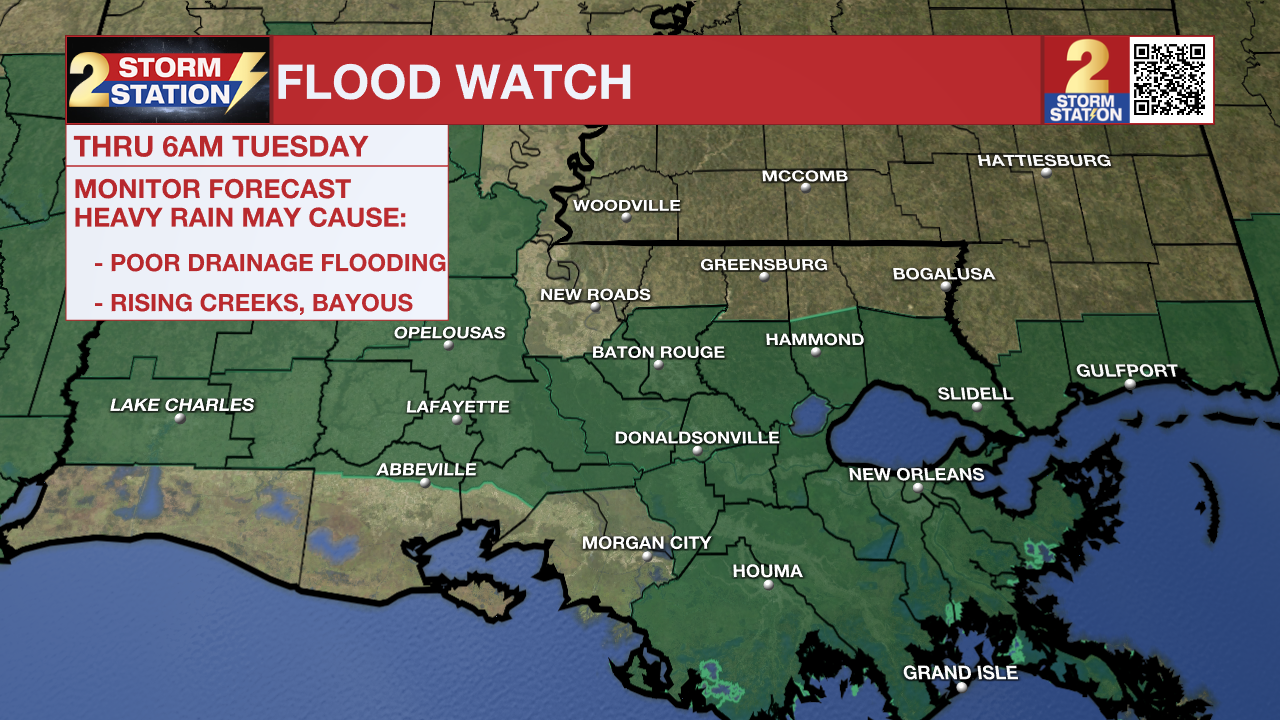
A FLOOD WATCH means conditions may develop that lead to flash flooding. Flash flooding is a very dangerous situation. Be on the lookout for threatening weather conditions and listen for later statements and possible warnings. For more on flooding safety, CLICK HERE.
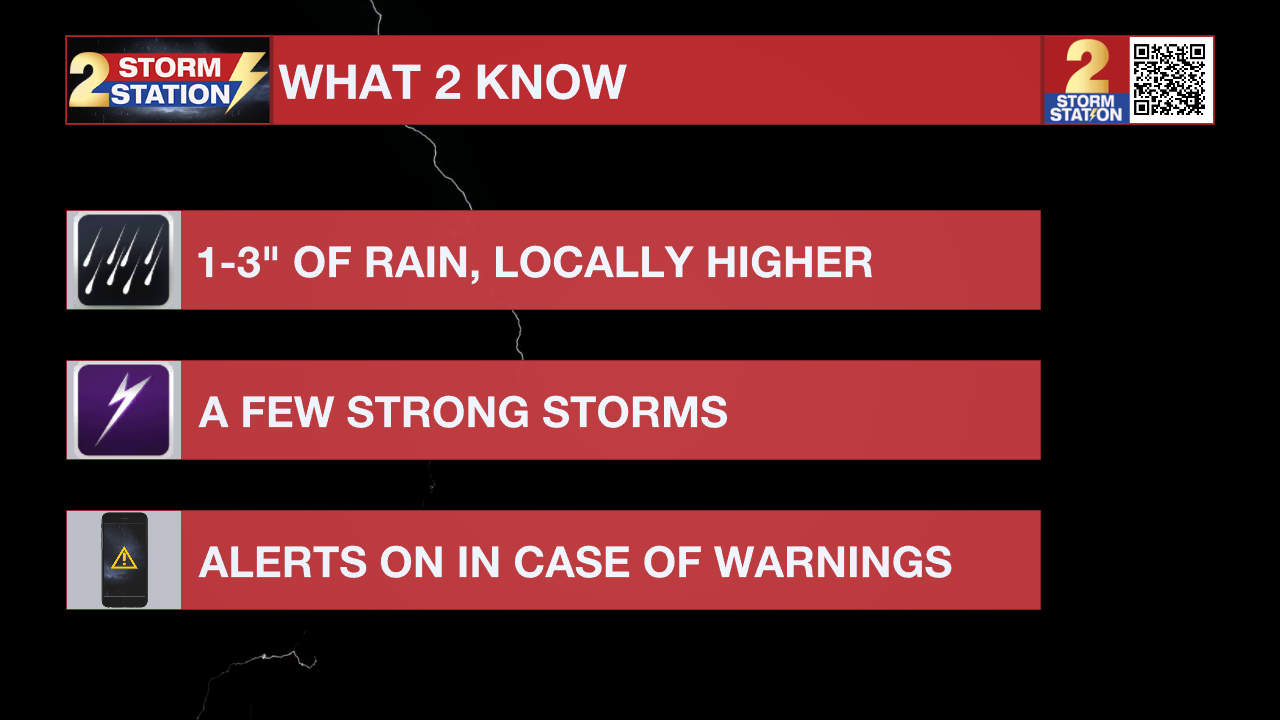
Multiple rounds of storms will be moving through the area throughout the next two days. 1 to 4" of rainfall with locally higher amounts in excess of 6" will be possible tonight through Tuesday morning, raising standing water concerns. Excessive runoff may result in flooding of rivers, creeks, streams, and other low-lying and flood-prone locations. Flooding may occur in poor drainage and urban areas.
Tonight & Tomorrow: Storms become more widespread closer to nightfall as a complex of storms in southwest Louisiana barrels east. The latest radar trends suggest a potent round of storms will move across southern Louisiana. A Severe T-Storm Watch is in effect until 12 a.m. Tuesday to account for this potential. These storms would be capable of strong damaging straight-line winds upwards of 70 mph, large hail, and perhaps an isolated tornado or two. Have weather alerts turned on heading into the evening in case severe weather strikes your community. You can download the FREE WBRZ Weather App HERE.
This round of storms might also result in flash flooding issues in spots that see too much rain in too short of a duration. All in all, most have the potential to pick up 1-3" of rain with locally higher amounts. A Flood Watch is in effect through 6 a.m. Tuesday to account for this threat.
After midnight, showers and storms quickly taper off. By daybreak, we will already begin to see clearing skies. Look for an overnight low near 68°. Aside from a few straggling clouds on Tuesday, skies will be mainly sunny. It will be warm with a high temperature in the upper-80s.
Up Next: Wednesday will be a quiet day with mostly sunny skies. Highs will trend even warmer, with a high in the low-90s. Fortunately, the humidity will be manageable. However, the humidity surges back into the area by late week. We will also see an corresponding increase in clouds on Thursday, plus showers showers beginning to arrive from the southwest. Rain chances stick around in the Storm Station 7-Day on Friday and into the weekend as well.
-- Meteorologist Malcolm Byron
Remember that the WBRZ WX App. is *free* on Apple and Android devices and can be used for breaking weather information, live radar, and forecast details. You can also use it to watch live coverage if power or broadcast signal is ever lost. For even more, connect with the Storm Station on Twitter and Facebook. Stream WBRZ+ for continuous information as it becomes available.
Click HERE to watch WBRZ streaming live online
Click HERE for the WBRZ weather page.
Click HERE to see how to download the WBRZ weather app.
Posts below are from the WBRZ Weather X account. Monitor for weather warnings below:
More News
