

Latest Weather Blog
Monday PM Forecast: tropical moisture will continue active pattern
In the midst of a wetter weather pattern, the Capital Area can expect healthy coverage in showers and thunderstorms through the middle of the week. Heat will be relatively muted thanks to the extra clouds and showers.
Tonight & Tomorrow: Beyond nightfall, showers and thunderstorms will gradually taper. Most of the nighttime hours will be dry. Low temperatures will settle out in the mid 70s due to humidity—the moisture left in place by earlier rain. Tuesday will be mostly cloudy with scattered showers and thunderstorms initiating by mid to late morning. Like previous days, any thunderstorms will be capable of downpours that produce nuisance street and poor drainage flooding, but widespread and major issues are not expected. High temperatures will be limited to the upper 80s as a result of increased cloud cover and precipitation.
Up Next: Deep tropical moisture will start to pull away from the Capital Area by the middle and end of the week. Wednesday through Friday will work out more like the typical summertime pattern. Enough heat and humidity will stick around to cause pop-up showers and thunderstorms during the afternoon and evening hours. Coverage will be lower than the beginning of the week with generally isolated activity. Also, in line with the normal routine, showers and thunderstorms will diminish overnight. By the end of the week, high temperatures will rebound into the low to mid 90s as a result of more dry time and sunshine.
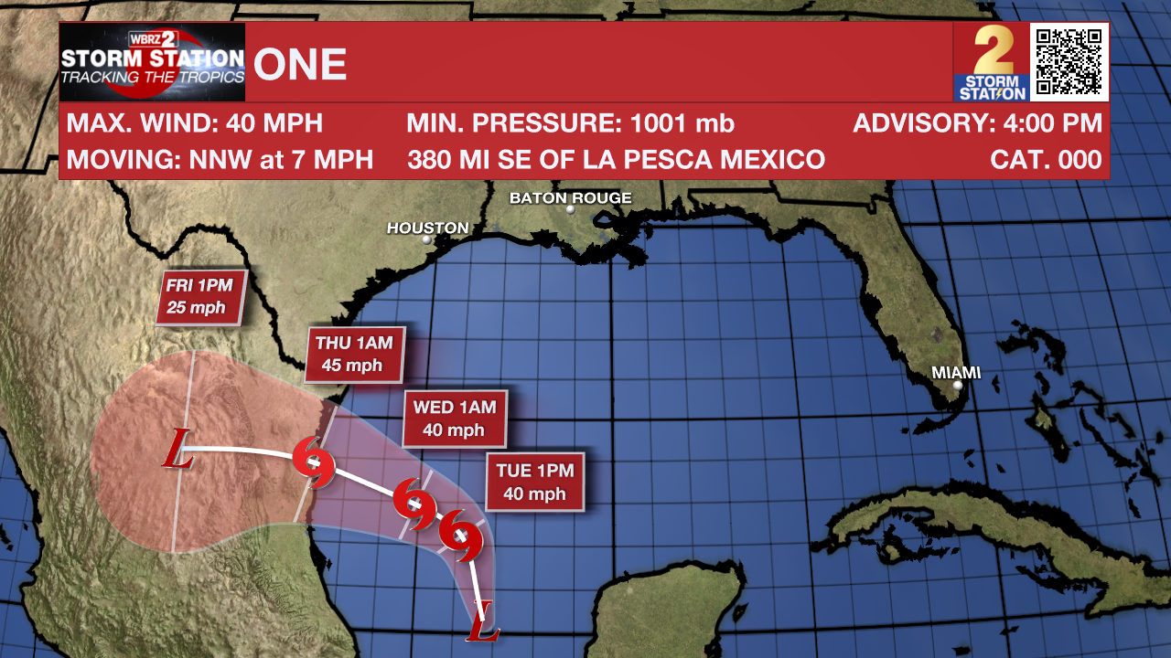
The Tropics: A low pressure system in the Bay of Campeche has been designated Potential Tropical Cyclone One. This designation is used by the National Hurricane Center when a system has not officially become a depression or storm but is expected to with imminent impact to land. No direct impacts are anticipated for the Capital Area. However, increased tropical moisture surrounding this system will aid in additional development of showers and thunderstorms through Tuesday. Gusty winds up to 35mph are possible, especially near the coast. You can view the complete forecast and outlook, HERE.
Trending News
An area of cloudiness and thunderstorms located several hundred miles east of the Bahamas is associated with a surface trough and an upper-level area of low pressure. Environmental conditions could be conducive for some development of this system during the next few days while it moves westward or west-northwestward. The system is forecast to approach the coast of the southeast United States on Thursday or Friday.
Get the latest 7-day forecast and real time weather updates HERE.
Watch live news HERE.
– Josh
The Storm Station is here for you, on every platform. Your weather updates can be found on News 2, wbrz.com, and the WBRZ WX App on your Apple or Android device. Follow WBRZ Weather on Facebook and Twitter for even more weather updates while you are on the go.
More News
