Monday PM Forecast: Rain has settled in, could stick around into Wednesday morning
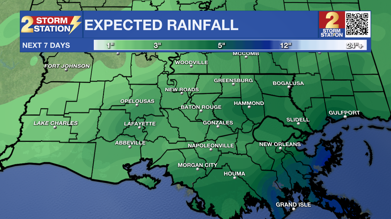
A broad area of light to moderate rain has settled in southeast Louisiana. This rain could potentially last into Wednesday morning.
Tonight & Tomorrow: An additional 1-3 inches of rain with isolated higher amounts is still possible. Rain is going to continue into the overnight hours with the best chances being around the Capital Area and south. In addition to that, cloud cover will slow cooling overnight, so we will only drop about five degrees to 57. Intermittent rain will still be around for the morning commute, so plan on leaving 5-10 minutes earlier when heading out in the morning. Visibility could be poor due to mist on the wet roads, so allow some extra space between cars. Remember, wipers on, headlights on! From daybreak through noon, showers will be more off and on in nature. However, another round of more widespread rain could come in during the evening hours on Tuesday. This will be during the commute again so keep caution when driving home. The plentiful cloud cover and rain will limit our high temperature to around 61 degrees. This rain is going to be mostly beneficial with the current drought situation. Even though it will be light to moderate, there still could be some nuisance standing water on the roadways.
Up Next: Rain could continue into the overnight hours on Tuesday, but it will be more scattered in nature. It will finally start to taper off by daybreak on Wednesday, but there will still be the chance of a spotty shower throughout the day. The second half of the workweek will be dry with some clouds sticking around. A shot of dry air could enter the area by Saturday which will finally get rid of most of the cloud cover. Our next best chance for rain looks to be at the beginning of next week.

Trending News
Get the latest 7-day forecast and real time weather updates HERE.
Watch live news HERE.
The Tropics: A broad area of low pressure is expected to form over the southwestern Caribbean Sea in the next few days. Environmental conditions appear favorable for additional development of this system thereafter, and a tropical depression is likely to form late this week while the system begins moving northeastward across the western and central portions of the Caribbean Sea. Interests in Jamaica, Haiti, and the Dominican Republic should monitor the progress of this system. Regardless of development, this system has the potential to produce heavy rains over portions of the Caribbean coast of Central America and the Greater Antilles towards to latter portions of this week.
-- Balin
The Storm Station is here for you, on every platform. Your weather updates can be found on News 2, wbrz.com, and the WBRZ WX App on your Apple or Android device. Follow WBRZ Weather on Facebook and Twitter for even more weather updates while you are on the go.


