

Latest Weather Blog
Monday PM Forecast: More extreme heat on Tuesday; Hurricane Beryl tracking through Caribbean
The hot streak of weather continues on Tuesday with highs soaring close to the century mark. To be expected, the humidity sticks around. This will push feels-like temperatures to dangerous levels for another day.
Tonight & Tomorrow: A few clouds will linger on Monday night. While a stray early evening shower is not out of the question, the overnight hours will be dry. Temperatures will struggle to cool as overnight lows only reach the upper-70s, close to 80°. Tuesday will bring more heat with a high temperature near 100°. As usual, the humidity will remain in full swing. Peak feels-like temperatures will be near 114-115°, which is right at the threshold to trigger an Excessive Heat Warning. Another one will be in place on Tuesday from 10 a.m. to 7 p.m.
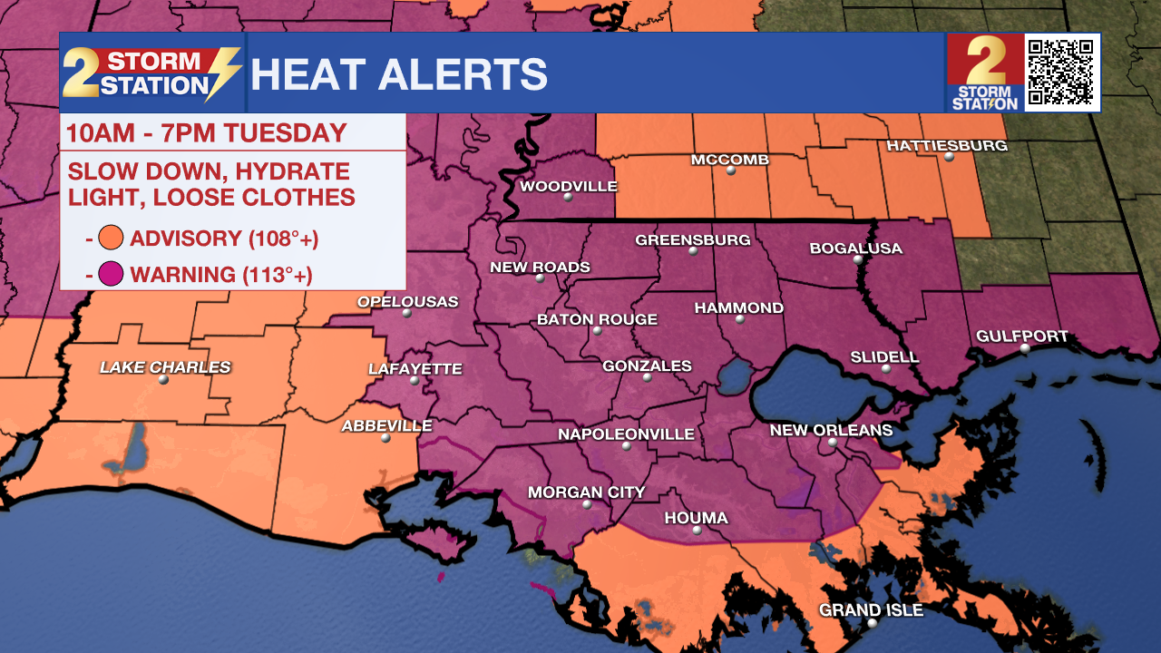
Yes, it is supposed to be hot in the summer months. However, the level of heat and humidity are reaching a point that is not quite as common – or excessive. Keep hydrating and taking breaks when outside for longer durations. Heat-related illnesses tend to become more common with each passing day in a hot streak since heat stress accumulates over time.
Isolated storms could develop, but a lesser rain coverage is anticipated on Tuesday due to a dry air influence. This will be about the only form of heat relief on Tuesday aside from a nice, air-conditioned room.
Up Next: Temperatures scale back slightly on Wednesday, but not by much. This will be in response to higher rain chances which could offer a little more heat relief. Even so, storms will be operating on a scattered basis on Wednesday. The Fourth of July is looking hazy, hot, and humid with the garden variety pop-up afternoon storms. With the loss of daytime heating, those storms should fade away after dark, which aligns nicely fireworks time. More of the same is expected into the weekend.
Trending News
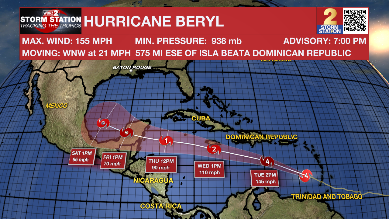
The Tropics: NOAA Hurricane Hunters indicate that maximum sustained winds have increased within Hurricane Beryl to 155 mph as of 7 p.m. Monday. That is a very strong Category 4 hurricane, but it is worth noting that Category 5 thresholds are 157 mph and above. Fluctuations in strength are possible in the next day or so. Should the storm attain Category 5 status, find out first via the FREE Storm Station Weather App.
This comes after Beryl made landfall on Grenada’s Carriacou Island Monday morning. The storm continues westward through the Caribbean Sea. The latest forecast track takes the storm near Jamaica, the Cayman Islands, and eventually the Yucatan Peninsula before moving into the Bay of Campeche. By midweek, the system will undergo gradual weakening. The Storm Station believes that the overall threat to Louisiana is low at this time. Major local impacts (if any at all) are unlikely. That said, parts of Mexico and south Texas should monitor the progress of this storm closely. The Storm Station will continue providing updates as they unfold.
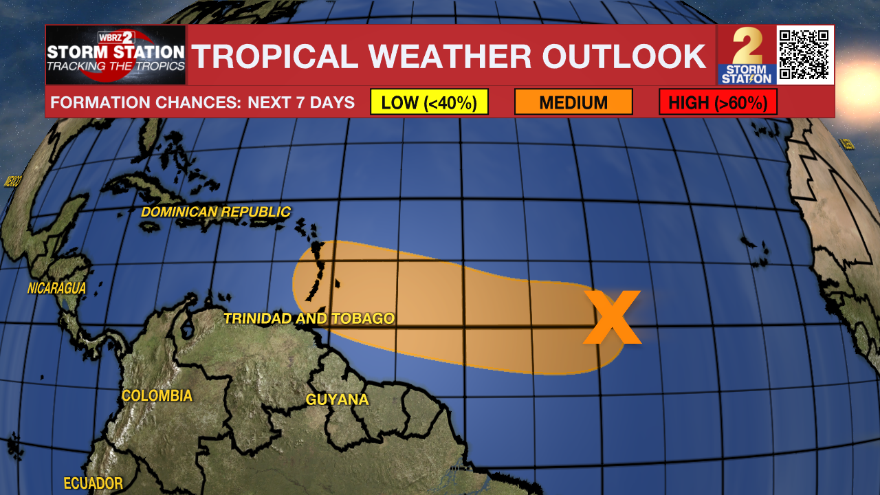
Another tropical wave is located over 1000 miles east-southeast of the Windward Islands, following in the footsteps of Beryl. This system now appears to have a slightly lower chance of development. Nevertheless, a tropical depression could form by the middle of the week as the disturbance moves west at 15-20 mph. Those in the Lesser Antilles, even some areas affected by Beryl, should monitor the progress of this wave.
Get the latest 7-day forecast and real time weather updates HERE.
Watch live news HERE.
-- Meteorologist Malcolm Byron
The Storm Station is here for you, on every platform. Your weather updates can be found on News 2, wbrz.com, and the WBRZ WX App on your Apple or Android device. Follow WBRZ Weather on Facebook and Twitter for even more weather updates while you are on the go.
More News
