Monday PM Forecast: midweek front to bring storms, cooler temps
Warm conditions will continue until a strong cold front barrels through around midweek. A few severe thunderstorms are possible along that front.
Next 24 Hours: A weak boundary pushed through the Capital Area on Monday with little fanfare. However, a slight change in wind direction may allow drier air into the morning and therefore low temperatures are expected the reach the low 60s. Tuesday will begin with plenty of sunshine but high clouds will increase through the day. Despite this, high temperatures will climb into the mid 80s.
Up Next: Wednesday will be the most active of the week. The morning will start muggy with temperatures in the upper 60s and there could be some low clouds and scattered showers around. These will substantially affect the forecast for later in the day. In short, more morning activity could lead to less of a severe weather threat later in the day. However, if the atmosphere remains untapped, a strong line of thunderstorms could produce gusty wind and brief tornadoes later in the day. As of now, a cold front is expected to send a squall line through the area between 2pm – 8pm Wednesday. In addition to strong storms, brief downpours could cause some issues as well. If you are a traditional commuter, stay in touch with the forecast, as the rush hour could be rather treacherous. Behind the front, it will become breezy, cooler and drier. Actually, while it will be more pleasant feeling with highs and lows in the 70s and 50s respectively, wind could remain gusty enough to create some issues on Thursday and possibly Friday. CLICK HERE for your full 7-Day Forecast.

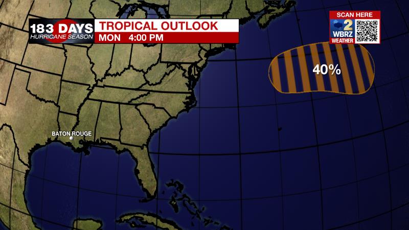
The Tropics: A non-tropical low pressure system is expected to form off the east coast of the United States by tonight. There is a 40 percent chance of development by the end of the week while it moves eastward over the central Atlantic. As we move into late October, it is increasingly rare for tropical systems to strike Louisiana. In fact, with records dating back to the 1860s, only four storms have made landfall past October 20. For the latest tropical forecasts, advisories and information, visit the WBRZ Hurricane Center as we navigate all 183 Days of Hurricane Season.
Trending News
The Explanation: Tuesday will bring tranquil conditions ahead of very active weather on Wednesday. High clouds will increase and thicken through the day as a bit of remnant moisture and energy from Pacific Tropical Storm Rick streams across skies. That moisture and energy will be steered eastward by a developing and deepening upper level trough over the Mountain West that will move into the local area on Wednesday. This upper level trough will be associated with a strong surface storm system and cold front that will move out of eastern Texas and into western Louisiana early on Wednesday. A line of strong thunderstorms is expected to move eastward across south Louisiana during the evening, reaching the central Gulf Coast sometime after midnight. Along the line, there will be ample moisture and strong wind shear. Instability could be limited and lead to thunderstorms with higher cloud bases, which would present more of a damaging wind than tornado threat. Still, when wind shear is sufficient, as it will be in this case, the strongest, deepest thunderstorms can still produce a brief tornado along the line. Of course, modeling and projecting severe weather always comes with some caveats and bust potential. In this case, the primary limit to storm achieving potential could be entirely too little instability created by morning clouds, and certainly any rain that can develop ahead of the main line. Even after the line passes through the area, the storm system will continue to bring impacts. Due to a sharp difference in temperature and therefore steep pressure gradient, winds will be elevated well into the end of the week. Sustained winds of 15-25mph are possible on Thursday and could remain at 10-20mph on Friday. Gusts over 35mph are possible. These stiff winds will usher in much cooler and drier air, but in keeping the atmosphere stirred up, low temperatures may not go as low as possible Friday and Saturday mornings. Still, temperatures will be a good 5 degrees or more below average through the weekend.
--Josh
The WBRZ Weather Team is here for you, on every platform. Your weather updates can be found on News 2, wbrz.com, and the WBRZ WX App on your Apple or Android device. Follow WBRZ Weather on Facebook and Twitter for even more weather updates while you are on the go.


