

Latest Weather Blog
Monday PM Forecast: dreary weather continues for much of week
A storm system will cross the Gulf of Mexico this week. Periods of rain and coastal flooding will result. This storm may resemble a tropical system but will not possess enough of the characteristics to be labeled as such. No matter the classification, the impacts to the area would not change.
Tonight & Tomorrow: We will still have a tough time shaking the mostly cloudy skies overnight. Low temperatures will stop in the upper 50s with northeast winds of 5-10mph. Tuesday will begin with mostly cloudy skies. Highs will wiggle into the mid 70s despite a cooling northeast breeze of 5-10mph. A storm system will be developing in the Gulf of Mexico and this will allow a few showers to brush the area later in the afternoon and evening hours.
A ***COASTAL FLOOD WARNING*** is in effect for areas surrounding Lake Maurepas and Lake Pontchartrain until 7am Thursday. Flooding of between 1 and 3 feet above ground level will be possible. Numerous roads may be closed. Low lying property including homes, businesses, and some critical infrastructure may be inundated. Some shoreline erosion may occur. Take the necessary actions to protect flood-prone property. If travel is required, do not drive around barricades or through water of unknown depth.
Trending News
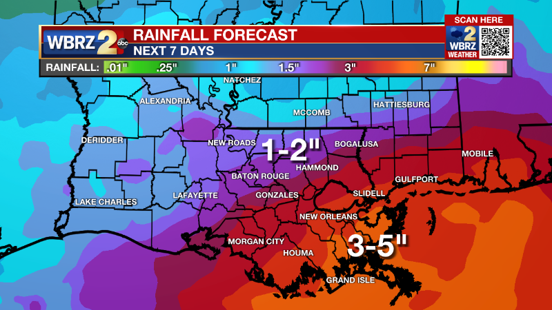
Up Next: As a storm system moves into the northern Gulf of Mexico, periods of rain are expected Wednesday through Thursday afternoon. Neither day is expected to be a total washout. At the same time, brief downpours are possible with rainfall amounts of an inch or two north and west of Baton Rouge to three or four inches south and east of Baton Rouge. No more than nuisance street flooding is expected from the rain. However, persistent east winds due to the slow-moving nature of the storm system could cause higher than usual tides and water inundation of one to four feet for east facing shorelines along the tidal lakes and coast. By Friday, the storm will push away to the east with briefly quieter weather before a cold front delivers another quick hit of showers and thunderstorms on Saturday.
Get the latest 7-day forecast and real time weather updates HERE.
Watch live news HERE.
--Josh
The Storm Station is here for you, on every platform. Your weather updates can be found on News 2, wbrz.com, and the WBRZ WX App on your Apple or Android device. Follow WBRZ Weather on Facebook and Twitter for even more weather updates while you are on the go.
.
More News
