

Latest Weather Blog
Monday PM Forecast: Baton Rouge weather pattern switch likely to block Grace
The tropics are busy but not threatening the local area. The summer weather rolls on with a bit of a pattern change coming late in the week.
JUST IN: #Fred makes landfall as a tropical storm with maximum winds of 65mph near Cape San Blas, Fl. according to @NHC_Atlantic. https://t.co/unixetInrq
— Josh Eachus (@DrJoshWX) August 16, 2021
The Tropics: As of 2:30pm Monday, Tropical Storm Fred made landfall near Cape San Blas, Florida with maximum winds of 65mph. Coastal flooding, gusty wind, isolated tornadoes and heavy rain will be issues across the Florida Panhandle, Alabama and Georgia through tonight. Those hazards may spread farther up the eastern seaboard on Tuesday.
Trending News
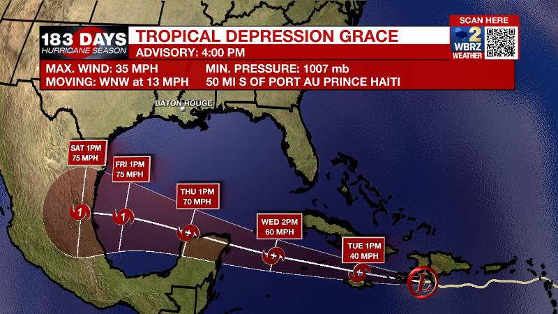
As of 4pm Monday, Tropical Depression Grace was producing torrential rain over Haiti and the Dominican Republic with maximum winds of 35mph. Grace will continue moving west-northwest at 10-15mph over the next several days, possible affecting Jamaica, Cuba and the Cayman Islands before approaching the Yucatan Peninsula late Wednesday. Grace may be near hurricane strength by this time. The storm is likely to remain across the southern third of the Gulf of Mexico and not affect the local area.
Just before 4pm Monday, Tropical Storm Henri formed in the central Atlantic. This system is expected to miss Bermuda and not impact the Gulf Coast.
For the latest tropical forecasts, advisories and information, visit the WBRZ Hurricane Center as we navigate all 183 Days of Hurricane Season.
Next 24 Hours: Any leftover showers will diminish by 11pm tonight. Low temperatures will stop around 73 degrees. Sun will be around through the first half of tomorrow. High temperatures will reach 92 degrees by 3pm. In the afternoon heat, scattered showers and thunderstorms will pop and last until about dusk.
Up Next: Wednesday and Thursday will continue the typical summertime rain rhythm and temperatures before a change comes. An upper level ridge of high pressure will build over the central Gulf Coast. This system will shield the local area from Tropical Storm Grace, but also cause slightly drier and warmer weather. Friday through Monday, rain coverage in the 13 Parish, 3 County Forecast Area will stay at 20 percent or less and high temperatures will reach the mid 90s with feels-like temperatures over 105 degrees. Another round of HEAT ADVISORIES may be needed. CLICK HERE for your full 7-Day Forecast.
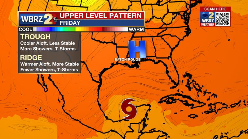
The Explanation: Typical August weather is expected through the first half of the week. Onshore flow from the Gulf of Mexico will keep warm, humid air over the area with above average moisture for the time of year injected through the atmosphere. In response to destabilization from daytime warming, scattered showers and thunderstorms will develop after high temperatures reach the low 90s. As you might expect, while severe weather is not anticipated, any thunderstorms will be capable of brief downpours and frequent lightning. Models hint at an uptick in activity for Thursday, possibly tied to a slug of enhanced tropical moisture moving across the Gulf Coast. By Friday, an upper level ridge will build across the region. The effects of this ridge will be two-fold. First, and more importantly, the clockwise circulation around the ridge will steer Tropical Storm Grace from east to west across the southern Gulf of Mexico, away from the local area. Therefore, no impacts are expected from that system. Second, the ridge will cause subsidence, or sinking air, will serves to suppress convection and cause even more warming. With humidity not going anywhere, the heat index will have no problem reaching the 105 – 110 range Friday through Monday as air temperatures peak in the mid 90s. This may cause the National Weather Service to issue Heat Advisories once again. Those days may not be entirely dry by showers and thunderstorms will be much more isolated and limited to the late afternoon.
--Josh
The WBRZ Weather Team is here for you, on every platform. Your weather updates can be found on News 2, wbrz.com, and the WBRZ WX App on your Apple or Android device. Follow WBRZ Weather on Facebook and Twitter for even more weather updates while you are on the go.
More News
