

Latest Weather Blog
Monday AM Forecast: Hot, humid, and mostly dry week ahead
A push of gulf moisture into the region Monday will send humidity levels back up to summertime mugginess. High humidity paired with above average heat and little rain will make for another extremely hot week in the Capital Area.
An *AIR QUALITY ALERT * has been issued for much of southern Louisiana on Monday. The Air Quality Index indicates that ozone will be at the orange level, which is Unhealthy for Sensitive Groups. Active children and adults, the elderly and people with respiratory diseases, such as asthma, should avoid prolonged outdoor activities and exertion. Several voluntary actions can help to reduce ozone formation such as driving less, refueling near dawn or dusk and conserving energy at home.
Today & Tonight: Monday will begin will mild conditions as clear skies overnight allowed temperatures to dip into the low and mid 70's around the region. During the day, gulf moisture will begin to seep into the Capital Area, resulting in an uptick in humidity back to summertime levels. Afternoon high temperatures will be in the middle to upper-90's with sunny skies during the morning featuring an increase in clouds by Monday afternoon. Rain remains spotty at best around the area this afternoon, though those lucky enough to run into a pop-up shower or storm should see quick relief from the heat. Heat index values this afternoon will remain just below Heat Advisory criteria (108°).
Tonight, the higher humidity values will not allow temperatures to cool as low as in previous nights. The Baton Rouge area will see temperatures fall just below 80° before daybreak Tuesday.
Up Next: Similar to last week, we are in for another streak of hot, steamy, and mostly dry days. All week, morning conditions will be muggy and warm with temperatures in the upper-70's and hot and humid afternoons in the upper-90's. With humidity reaching extreme levels again during the week, multiple days of heat alerts will not be out of the question again this week. Even when alerts are not issued, the Storm Station advises to continue to prioritize heat safety.
High pressure will dominate the region all week, keeping rain chances very slim. Each day features around 20%, or very spotty coverage of afternoon storms.
The Tropics: The National Hurricane Center has begun issuing advisories on Potential Tropical Cyclone (P.T.C.) Five, located a little less than 650 miles east of the Lesser Antilles early Monday morning. The "potential tropical cyclone" terminology is used when a disturbance has yet to acquire tropical characteristics, but will likely do so within 48 hours and impact land. Several Tropical Storm Watches have been issued for parts of the Leeward Islands.
Trending News
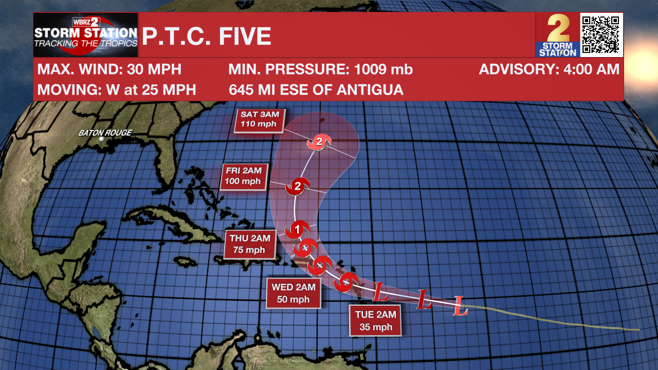
P.T.C. Five will likely become a tropical storm early this week, taking the name Ernesto once that happens. A landfall somewhere in the Leeward Island chain and possibly Puerto Rico could occur by midweek as the storm intensifies to near-hurricane strength. Afterward, most data suggest a recurve scenario toward the general direction of Bermuda. The Storm Station does not anticipate any impacts in Louisiana at this time.
Get the latest 7-day forecast and real time weather updates HERE.
Watch live news HERE.
- Emma Kate C.
The Storm Station is here for you, on every platform. Your weather updates can be found on News 2, wbrz.com, and the WBRZ WX App on your Apple or Android device. Follow WBRZ Weather on Facebook and Twitter for even more weather updates while you are on the go.
More News
