

Latest Weather Blog
Monday AM Forecast: Front delivers isolated storms today, Drier air for the week
After reaching 100° for the 5th and 6th time this year over the weekend, we are due for some much needed relief from the extreme heat. A "cool" front arriving Monday will bring lower humidity to the region, resulting in less extreme conditions.
Today & Tonight: A few rounds of storms developing in Arkansas early Monday may hold together long enough to bring a few rounds of isolated storms to southern Louisiana throughout the day on Monday. Coverage with these storms looks to be spotty to isolated at best, but those that do see storms could be in for gusty winds and heavier downpours at times.
Overall, Monday will be the final day of oppressive heat before relief in the form of a frontal system bringing lower humidity arrives. Today, temperatures will climb into the middle 90's with a few parishes seeing heat index values above Heat Advisory criteria this afternoon. Expect a mix of sun & clouds with plenty of dry time between possible isolated storms. Once the front slowly arrives late Monday, a push of drier air will filter into the state. By early Tuesday, morning lows will fall into the low and middle 70's with a less muggy feel to start the day.
Up Next: While the "cool" front will bring relief from the extreme conditions, each afternoon will remain hot through the workweek, with highs in the middle to upper-90's around the Capital Region. The good news is that with limit humidity, the heat index values will not be able to rise much above the actual forecast temperatures. The most comfortable parts of the coming days will be the early morning and later evening hours. Low temperatures this week will fall back near normal for this time of year, into the lower-70's and even dipping into the upper-60's for northern parishes and Mississippi counties! With the drier air in place, rain becomes slim to none during the workweek. By Friday, the steam machine will begin to crank back up as gulf moisture returns to the area just in time for the weekend.
The Tropics: Ernesto remains a Category 1 Hurricane as of early Monday morning. The storm may maintain hurricane status for another day before weakening to a tropical storm on Tuesday. By midweek, Ernesto will likely be a strong post-tropical system accelerating eastward into cooler waters.
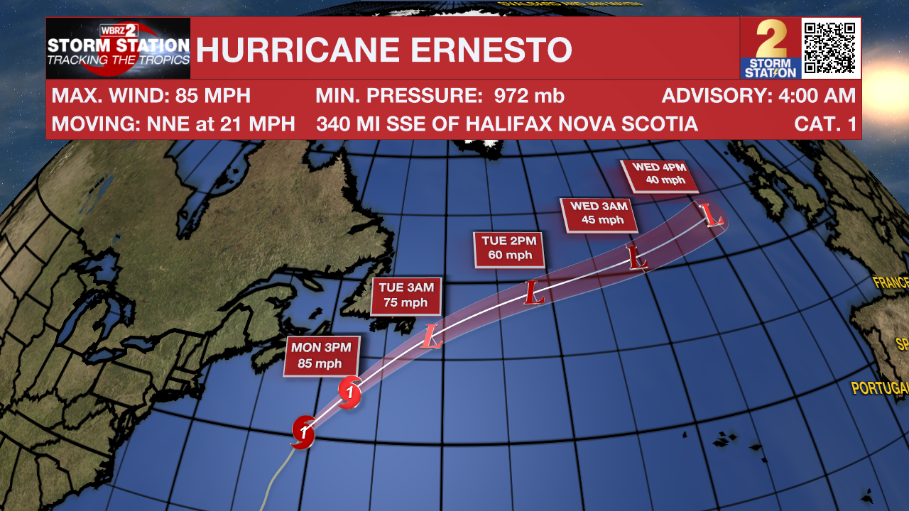
There are no other areas of concern in the Atlantic Basin at this time.
Trending News
Get the latest 7-day forecast and real time weather updates HERE.
Watch live news HERE.
- Emma Kate C.
The Storm Station is here for you, on every platform. Your weather updates can be found on News 2, wbrz.com, and the WBRZ WX App on your Apple or Android device. Follow WBRZ Weather on Facebook and Twitter for even more weather updates while you are on the go.
More News
