

Latest Weather Blog
Friday PM Forecast: temperatures to stay well above average right through Halloween
Outdoor plans for Friday night and Saturday are in good shape. Any chance for an organized rain shower remains absent until at least the middle of next week. Temperatures will stay about 10 degrees above average.
The Weekend: With mainly clear skies, overnight low temperatures will settle near 60 degrees. Ongoing, gradual return of moisture will make patchy fog possible, especially near bodies of water. Any fog or morning clouds will quickly give way to sunshine and send high temperatures to near 90 degrees each afternoon. The record high for Saturday is 90 degrees, set in 1939 and 1921. The record high for Sunday is out of reach at 95 degrees.
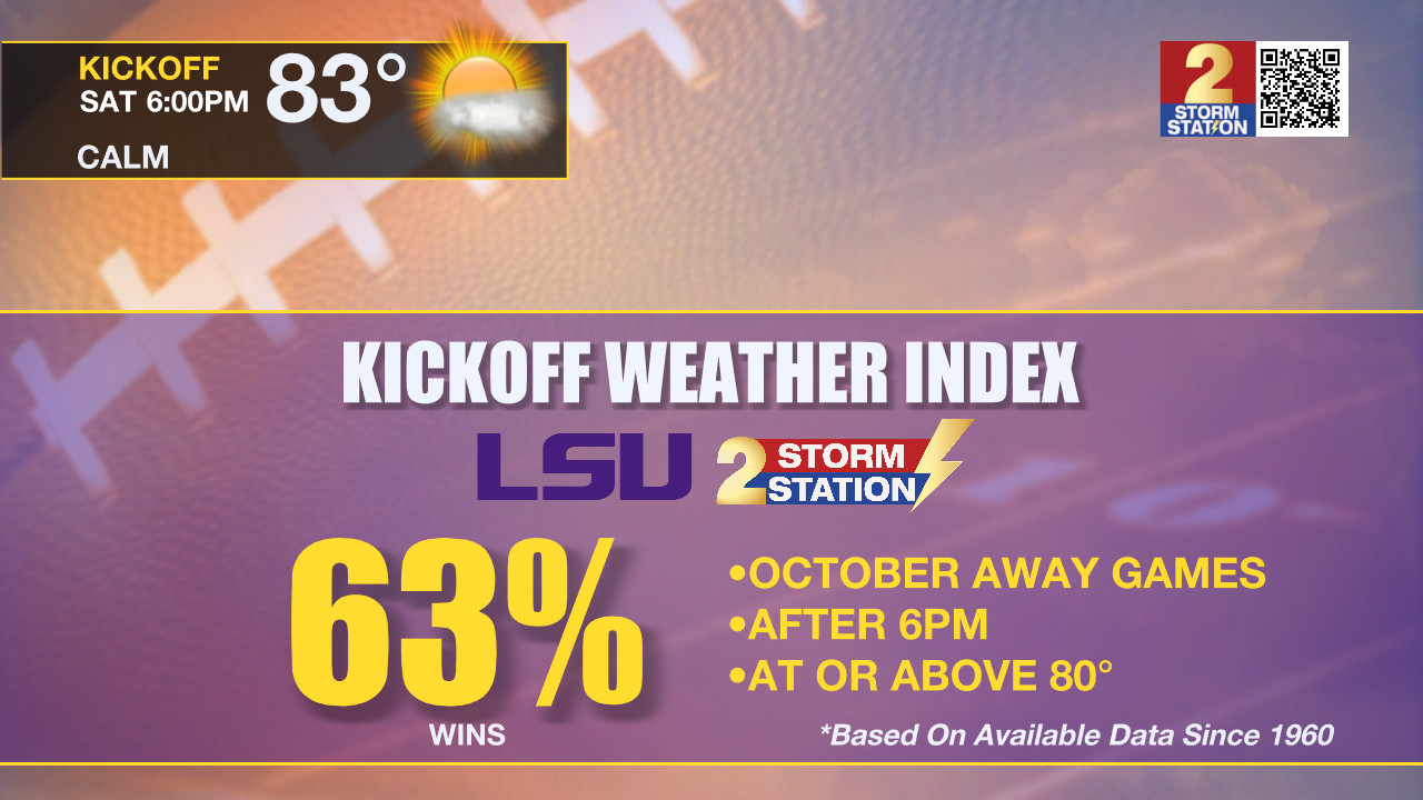
Away Football Games: Both Capital Area teams will be hitting the road this weekend for two highly anticipated match-ups. As LSU takes on Texas A&M Saturday night in College Station, fans should expect warm tailgating conditions that afternoon with temperatures in the upper 80s under mainly sunny skies. According to the LSU Kickoff Weather Index, this will be the latest game into the calendar year that LSU has played on the road at night with a kickoff temperature above 80 degrees. Similar conditions are expected in Tallahassee, FL as Southern takes on Florida A&M. The evening kickoff will be mild after a warm afternoon full of sunshine and highs in the mid 80s. Thermometers will end up in the 70s by the end of the game. Fans heading to Florida or Texas this weekend will not need to pack any raingear but don't forget the sunglasses!
Up Next: Early next week, a cold front will be moving into the Lower Midwest. First things first, this front will not reach the Capital Area. However, increasing winds associated with the front will start to mitigate morning fog development. Moisture will continue to pool up ahead of the front. At first, this moisture will support some low cumulus cloud development early in the week. As the moisture gets deeper, skies will turn mostly cloudy later in the week with spotty showers even becoming possible Wednesday through Friday. On Monday and Tuesday highs will be in the upper 80s with lows in the low 60s. The temperature range will shrink later in the week due to the added moisture and clouds with highs in the mid 80s and lows in the mid 60s.
Trending News
Get the latest 7-day forecast and real time weather updates HERE.
Watch live news HERE.
The Tropics: After a long active period, the Gulf of Mexico, Caribbean Sea and Atlantic Ocean are quiet. No tropical development is expected over the next seven days.
– Josh
The Storm Station is here for you, on every platform. Your weather updates can be found on News 2, wbrz.com, and the WBRZ WX App on your Apple or Android device. Follow WBRZ Weather on Facebook and Twitter for even more weather updates while you are on the go.
More News
