

Latest Weather Blog
Friday PM Forecast: stalling front to reintroduce widespread storms
As we move into the month of September, many start looking for the first signs of a fall feel. At least through the first quarter of the month, that will not come. The humid, wet pattern will continue.
Next 24 Hours: Expect partly cloudy skies overnight with low temperatures around 75 degrees. Saturday may start with some sunshine as high temperatures chug up to about 88 degrees. With tropical moisture back in the atmosphere, scattered showers and thunderstorms will develop by late morning and early afternoon. Be sure to have an indoor option nearby in the event of lightning.
Football Forecasts: For the Jags, showers and thunderstorms will be settling down into the evening hours. However, some leftover rain could keep conditions soggy closer to kickoff at 6pm. Likewise, Tigers fans out and about in New Orleans should be prepared to dodge thunderstorms Sunday afternoon. After the game, the drive back to Baton Rouge will be dry.
Up Next: Much like the weekend began; Sunday will be mostly cloudy with scattered showers and thunderstorms, morning lows in the mid 70s and afternoon highs in the upper 80s. Higher rain coverage with slow moving thunderstorms for a few consecutive days could again heighten the concerns for street and poor drainage flooding through at least Monday. Confidence is low in the forecast for the middle and end of next week. Guidance in the pattern is split between remaining wet or trending drier. Check back in for updates as the details work out over the weekend. Either way, there are not yet any signs of a significant front to reduce humidity. CLICK HERE for your detailed 7-Day Forecast.
Trending News
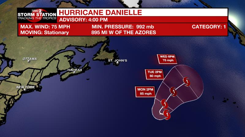
The Tropics: On Friday, Danielle became the first hurricane of the season. As of 4pm, maximum sustained winds were at 75mph with additional strengthening expected over the next few days. Nearly stationary through the weekend, the hurricane will turn northeast and accelerate next week.
An area of low pressure located a few hundred miles east of the Leeward Islands continues to produce disorganized showers and thunderstorms, mainly over the eastern portion of the circulation. Environmental conditions remain only marginally conducive, but there is still a seventy percent chance that a tropical depression can develop. The disturbance is expected to move slowly west-northwestward, toward the adjacent waters of the northern Leeward Islands.
The Explanation: The front responsible for the drier air will retreat north and stall Friday into the upcoming weekend. With deeper tropical moisture returning, scattered to widespread showers and thunderstorms will develop. Steering winds will be light and so movement will be based on marine breezes and storm outflow. The wet pattern will persist early next week. An upper level trough of low pressure will remain anchored across the Gulf Coast providing a continuous flow of tropical moisture for a few days. This setup favors efficient, rain processes in thunderstorms. Since the area is only just beginning to dry out from a wet August, any spot that is hit with multiple heavy storms in a few days could have some nuisance flooding issues develop. Rain coverage each day will peak in the afternoon hours with convection likely diurnally driven and mostly focused along sea and lake breeze boundaries. With the increase in shower and thunderstorm activity, high temperatures will be several degrees cooler in the mid 80s.
--Josh
The Storm Station is here for you, on every platform. Your weather updates can be found on News 2, wbrz.com, and the WBRZ WX App on your Apple or Android device. Follow WBRZ Weather on Facebook and Twitter for even more weather updates while you are on the go.
More News
