

Latest Weather Blog
Friday PM Forecast: P.T.C. Four heads for Florida, heat continues into weekend
A * HEAT ADVISORY* is in effect from 10am to 7pm Saturday as feels-like temperatures up to 113 degrees are expected across the entire Storm Station Forecast Area. Hot temperatures and high humidity may cause heat illnesses. Drink plenty of fluids, and when possible, stay in an air-conditioned rooms, avoid afternoon sun, and check up on relatives and neighbors.
Tonight & Tomorrow: Skies will gradually clear overnight with well above average low temperatures continuing. The standing record warm minimum is 82 degrees but most locations should slip just below that into the low 80s. The first half of the weekend offers the best, though still small, opportunity for isolated showers and thunderstorms. Any activity should pop ahead of a weak front that will approach during the late afternoon hours, bringing measurable rain to about 30-40% of the 13 Parish, 2 County Forecast Area. It is also possible that any storm could produce gusty wind. Unfortunately, the showers, thunderstorms and any associated clouds will occur later in the day allowing plenty of time for warming into the mid 90s and feels like temperatures to eclipse 108 degrees.
Up Next: Any reprieve in the form of late day showers and thunderstorms will be short lived and total activity will tick back down for the second half of the weekend. The atmosphere is expected to dry significantly on the western side of a tropical system in the eastern Gulf of Mexico. Rain coverage should be at 10% or less Sunday through at least Tuesday. You may be able to detect a slight drop in humidity, very slight, but make no mistake that temperatures will stay hot and above average. Through much of next week, lows will be in the upper 70s and highs will be in the upper 90s.
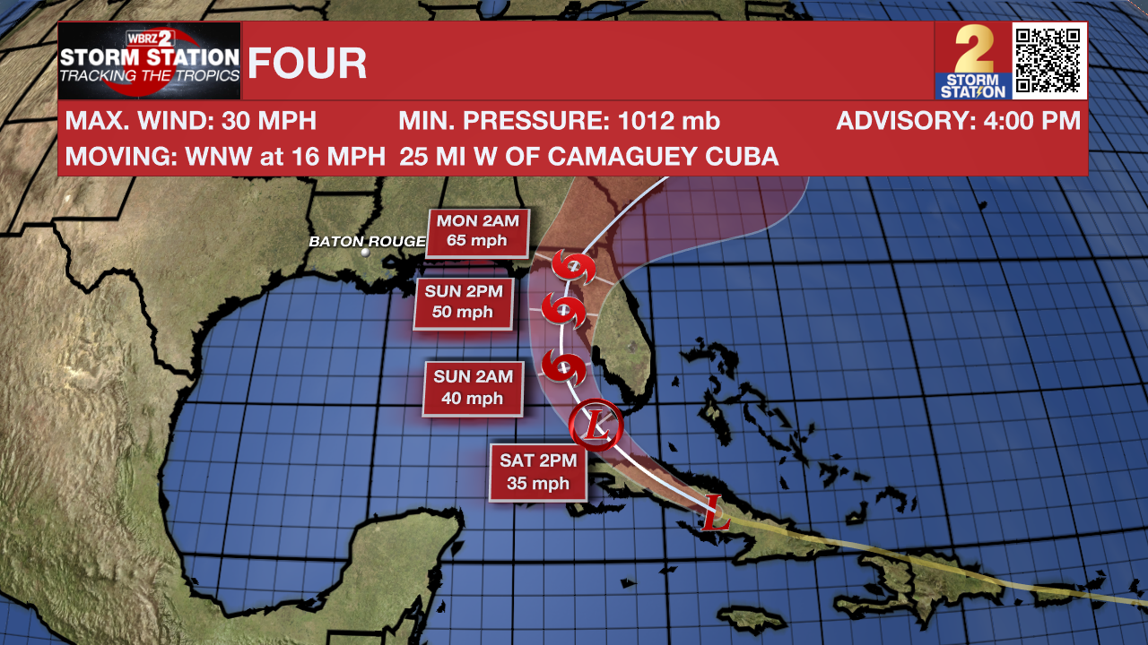
The Tropics: A tropical disturbance moving across Cuba is expected to move into the eastern Gulf of Mexico and become a tropical storm this weekend. Since the system may affect land within 48 hours, but has not yet developed, the National Hurricane Center has designated Potential Tropical Cyclone Four to activate their array of bulletins. Four will slow down and turn northwest on Saturday and then north on Sunday before moving inland as a tropical storm across the peninsula of Florida. There, tropical storm force winds, surge and heavy rain can be expected.
Trending News
Get the latest 7-day forecast and real time weather updates HERE.
Watch live news HERE.
– Josh
The Storm Station is here for you, on every platform. Your weather updates can be found on News 2, wbrz.com, and the WBRZ WX App on your Apple or Android device. Follow WBRZ Weather on Facebook and Twitter for even more weather updates while you are on the go.
More News
