

Latest Weather Blog
Friday PM Forecast: low humidity persists, tropics remaining highly active
Generally pleasant conditions and benign weather will dominate the forecast. The tropics are getting rather active and there could be another system to monitor by the end of next week.
Tonight & Tomorrow: Skies will remain mostly clear overnight and low temperatures will again dip into the mid 60s. Saturday will be comfortably warm with high temperatures heading for the upper 80s with a lot of sunshine. You may notice a light, west breeze of 5-10mph.
LSU Football: LSU Football will kickoff in Tiger Stadium against South Alabama at 6:30pm CST. The Storm Station forecast calls for a kickoff temperature of 80 degrees beneath mostly sunny skies. With much lower humidity, feels-like temperatures will be nearly 20 degrees cooler than during the UCLA game, plus the entire stadium will be shaded quickly as sunset approaches. See what the weather conditions mean for the Tigers chances in our Kickoff Weather Index.
Up Next: Sunday will bring at least one more comfortable morning with low temperatures in the upper 60s. A little moisture will sneak in during the afternoon hours allowing some cumulus clouds to develop as high temperatures go into the upper 80s. You still won’t notice much humidity through the weekend but that will change early next week. Though we don’t expect summertime steam, it will feel more sticky than recent days. However, rain will be hard to find through the remainder of the forecast with temperatures only gradually working back above average by the middle of next week. A weak, reinforcing front will push through on Wednesday and keep humidity from returning to that summery steaminess.
Get the latest 7-day forecast and real time weather updates HERE.
Trending News
Watch live news HERE.
The Tropics: Post Tropical Helene continues to produce catastrophic flooding over potions of the Appalachians and Tennessee Valley. The maximum sustained winds have lessened to 35mph, the slowing forward motion to the northwest will allow torrential rain to continue across portions of the Carolinas, Virginia, West VirginIa, Ohio, Indiana, Kentucky, Tennessee, Illinois, Missouri and Arkansas.
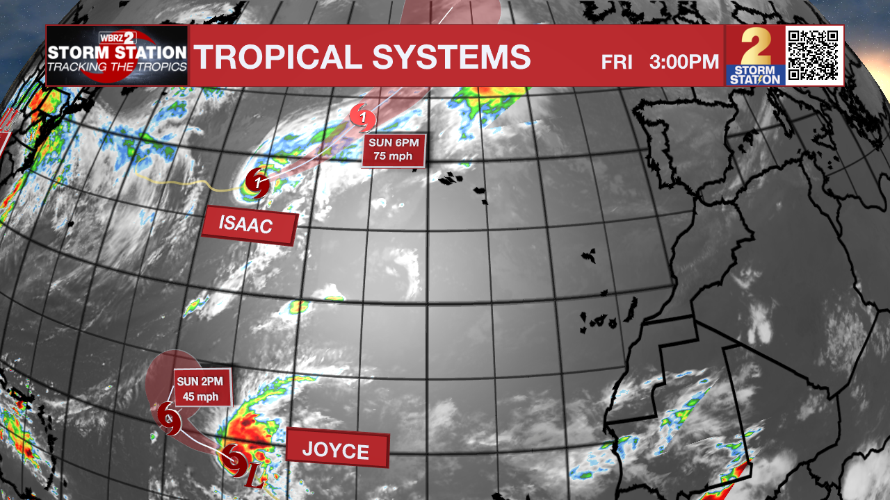
Tropical Storm Joyce is strengthening across the central Atlantic Ocean. With maximum sustained winds of 50mph, the storm could get a little stronger before gradual weakening next week as the storm turns north over open water.
Hurricane Isaac continues to get stronger across the north, central Atlantic Ocean. The system is moving east at 15mph with 85mph winds and could get stronger before turning northeast into cooler water this weekend. The storm could send high swells toward The Azores.
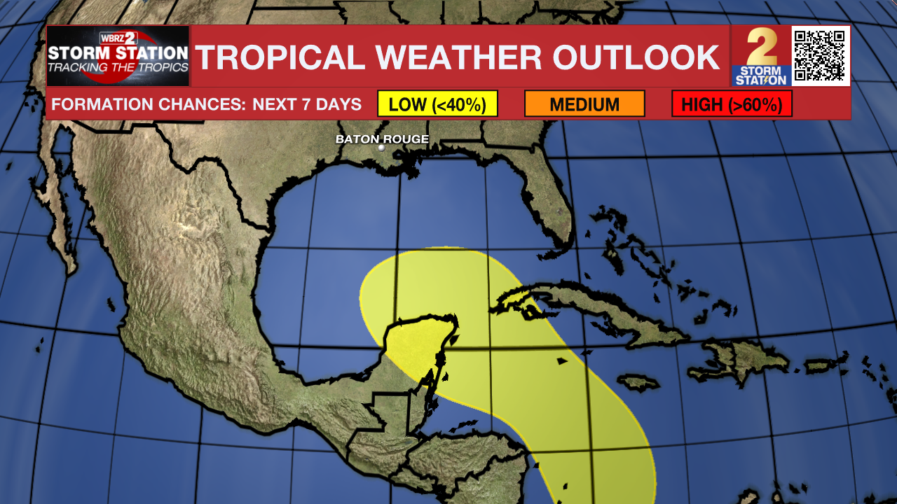
An area of low pressure could form over the western Caribbean Sea by the middle of next week. Environmental conditions are expected to be conducive for slow development thereafter while the system moves generally northwestward, potentially entering the Gulf of Mexico by the end of next week.
An area of low pressure could form over the eastern tropical Atlantic by the early to middle part of next week. Environmental conditions are expected to be conducive for slow development thereafter while the system moves generally northwestward at 10 to 15 mph.
– Josh
The Storm Station is here for you, on every platform. Your weather updates can be found on News 2, wbrz.com, and the WBRZ WX App on your Apple or Android device. Follow WBRZ Weather on Facebook and Twitter for even more weather updates while you are on the go.
More News
