

Latest Weather Blog
Friday AM Forecast: The heat is here and it is sticking around
The story for this weekend: Hot, Hotter, Hottest
THE FORECAST
Today & Tonight: Waking up to clear skies and temperatures in the mid-70s this morning. Temperatures will continue to rise into the mid-90s by the afternoon hours. Heat index temperatures will be in the triple digits for several hours today. Heat Advisory is in effect for today for the Capital Area. Most will stay completely dry today, but a shower is possible in the afternoon hours. Overnight we will cool off into the mid-70s.
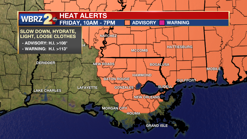
*HEAT ADVISORY* for the shaded area. Keep an eye on kids, pets, the elderly and check the backseat! #lawx #mswx Our latest forecast: https://t.co/1NFYtqf6dL pic.twitter.com/9d9nZKW8ry
— WBRZ Weather (@WBRZweather) June 17, 2022
Trending News
Sun and Heat Safety: Some friendly reminders for your summer of fun events—sunburn can occur in less than 15 minutes with the extreme U.V. Index typical of this time of year. In addition to that, heat exhaustion and heat stroke can set in just as quickly. Seek medical attention if you or somebody you know is affected. While we all enjoy a list of cool beverages, be sure water is at least a part of that list! Finally, look before you lock. DO NOT leave people or pets in an unattended car.
Up Next: The weekend is shaping up to be a hot one. Waking up to temperatures in the mid-70s with mostly sunny skies. Temperatures will continue to climb into the high 90s over the weekend. Saturday some cooling showers are expected in the afternoon hours. Most will stay dry but those who see a shower will get some brief relief from the heat. As we head into Sunday, we will see more drying out in our forecast. This will give us ample opportunity to heat up into the high-90s, some might even see 100°, throughout the week. Feels like temperatures will be in the triple digits, expect the heat advisories to continue into next week.
Click here to see the 7-day forecast.
Hour-by-hour weather tracking is available for your location on the WBRZ WX App on your Apple or Android device. Follow WBRZ Weather on Facebook and Twitter for even more weather updates and unique weather insight from the whole team!
In the Tropics:
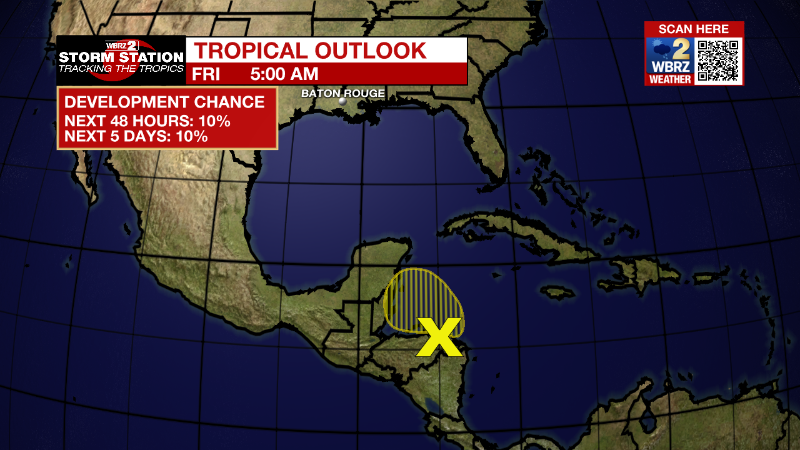
Northwestern Caribbean Sea:
A trough of low pressure located along the coast of Honduras is
producing disorganized showers and thunderstorms over the
northwestern Caribbean Sea. Some gradual development is possible
today while the disturbance drifts west-northwestward over the Gulf
of Honduras. Subsequent development is unlikely once the system
moves inland over northern Central America and southeastern Mexico
Saturday. Regardless of development, locally heavy rainfall is
possible over Honduras, Belize and southeastern Mexico through the
weekend.
* Formation chance through 48 hours...low...10 percent.
* Formation chance through 5 days...low...10 percent.
More News
