

Latest Weather Blog
Friday AM Forecast: sunny & warm through weekend, coolest temps of season next week
The streak of sunny skies and warm high temperatures will continue into the weekend. Next week, a strong cold front will arrive bringing the coolest temperatures of the season.
Today & Tonight: After a cool morning start, highs will drastically climb because of sunny skies. Most will get into the lower 90s, which is above average for this time of year. The good news is humidity will stay in check. Overnight, it will get cool once again, will lows near 61 degrees.
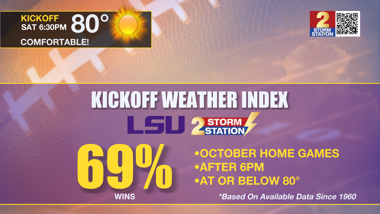
Saturday & LSU Football: You may want a light jacket for tailgating on Saturday morning. However, extra layers will be lost for short sleeves and shorts as sunshine pushes temperatures into the 80s during the afternoon. As LSU takes on Ole Miss at 6:30pm in Tiger Stadium, temperatures will be in the upper 70s. The LSU Kickoff Weather Index shows the Tigers winning 69% of October home games after 6pm when temperatures are below 80 degrees.
Up Next: By Sunday, mugginess will start to creep back into the region. This combined with highs in the lower 90s will make it feel a bit uncomfortable in the afternoon and evening. This uptick in humidity will be short lived, as a strong cold front will pass through Monday evening. Temperatures will be significantly lower next week! Highs will dip into the 70s by Wednesday, with lows in the lower 50's.
Trending News
Get the latest 7-day forecast and real time weather updates HERE.
Watch live news HERE.
The Tropics: What was Hurricane Leslie, is now a tropical storm with 60mph winds. Moving north at 10mph, the storm will turn northeast Saturday and rapidly weaken.
Shower and thunderstorm activity has become better organized in association with an area of low pressure located over the Cabo Verde Islands. Some additional development is possible and a short-lived tropical depression or tropical storm could form while the system moves westward or west-northwestward at 10 to 15 mph across the Cabo Verde Islands and eastern tropical Atlantic today. By Saturday, environmental conditions are forecast to become less conducive, and further development is unlikely after that time. Regardless of development, localized areas of heavy rain and gusty winds are possible across portions of the Cabo Verde Islands today.
---Balin
The Storm Station is here for you, on every platform. Your weather updates can be found on News 2, wbrz.com, and the WBRZ WX App on your Apple or Android device. Follow WBRZ Weather on Facebook and Twitter for even more weather updates while you are on the go.
More News
