

Latest Weather Blog
Friday AM Forecast: HOT weekend ahead, Staying dry until Father's Day
Father's Day weekend will start off with near record heat and end with an increased chance for showers and storms.
Today & Tonight: Hot and dry conditions will be around to conclude the workweek. Afternoon temperatures on Friday in the Capital Area are likely to heat into the middle and upper 90's as upper-level ridging takes over the state. This ridging will keep rain chances at bay and sunshine dominating for the first half of the weekend. Overnight lows will dip into the low to mid 70's once again with mostly clear skies.
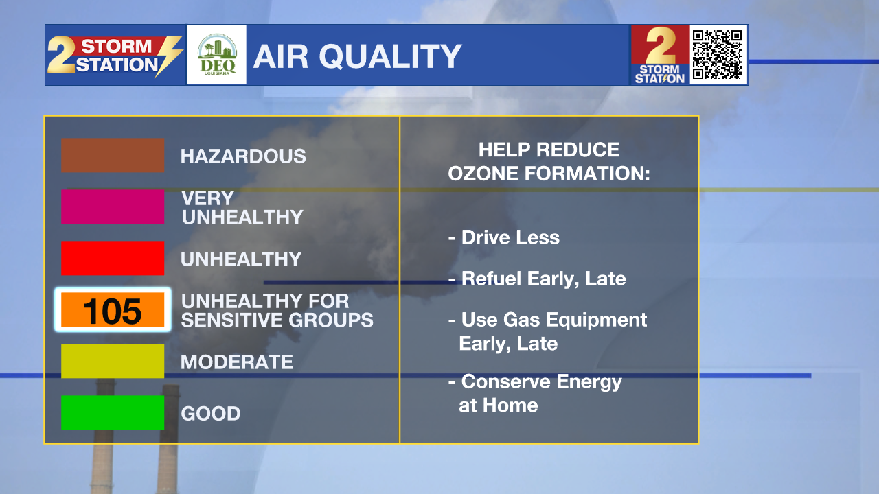
Through Saturday, elevated ground level ozone amounts will make the air quality unhealthy for sensitive groups in the metro area. It is advised to limit time outdoors, especially during afternoon hours, over the next few days if you are sensitive to elevated ozone levels.
Up Next: Saturday will likely be the hottest day of the week, and possibly so far this year, as the forecasted high temperature in Baton Rouge is 99°. The previous record high for June 15th is 100° set back in 1963. The unseasonably hot weather will come to an end on Father's Day as a surge in atmospheric moisture from the gulf will increase cloud cover and rain chances, keeping temperatures closer to average for the middle of June, in the lower-90's. As of the latest data, coverage of Father's Day showers and storms looks to gradually increase throughout the day and from the south to the north through the area. Scattered showers will be most likely in the afternoon and evening hours. If you have outdoor plans on Father’s Day, plan for some occasional indoor adjustments, but a washout is not anticipated.
Trending News
The push of gulf moisture into the area is thanks to a deep plume of tropical air that will take over the western gulf coast next week. For southern Louisiana, this will bring scattered rain chances to the forecast through at least the middle of next week. Monday and Tuesday seem to hold the greatest chance for scattered to numerous showers and although there is not a major concern for flooding, it it important to remember that summer thunderstorms are always capable of creating isolated pockets of poor drainage flooding. The wetter pattern will keep temperatures slightly below average.
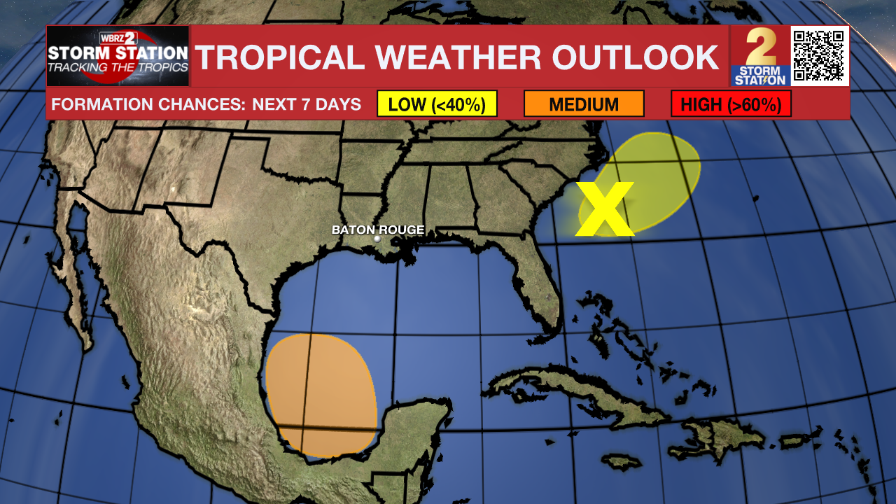
The Tropics: An elongated area of low pressure offshore the southeastern U.S coast is producing a large area of disorganized showers and thunderstorms. Despite strong upper-level winds, some gradual development is possible while the system moves northeastward offshore of the southeastern U.S. coast during the next day or so. Regardless of development, heavy rainfall is forecast to continue across portions of the Florida peninsula through late this week. For more information, see products issued by the Weather Prediction Center and local National Weather Service Forecast Offices.
A broad area of low pressure is forecast to form over the southwestern Gulf of Mexico over the weekend. Environmental conditions appear conducive for gradual development of this system, and a tropical depression could form during the early or middle part of next week while it moves slowly westward or west-northwestward. That system is not expected to affect the local area with the exception of providing increased moisture for showers and thunderstorms.
Get the latest 7-day forecast and real time weather updates HERE.
Watch live news HERE.
– Emma Kate Cowan
The Storm Station is here for you, on every platform. Your weather updates can be found on News 2, wbrz.com, and the WBRZ WX App on your Apple or Android device. Follow WBRZ Weather on Facebook and Twitter for even more weather updates while you are on the go.
More News
