

Latest Weather Blog
Friday AM Forecast: Extreme heat continues into weekend, Tracking tropical wave in Caribbean
An *EXCESSIVE HEAT WARNING* is in effect from 10am to 7pm Friday for East Baton Rouge parish and areas east and south as feels-like temperatures up to 115 degrees are expected across the entire Storm Station Forecast Area. Hot temperatures and high humidity may cause heat illnesses. Drink plenty of fluids, and when possible, stay in an air-conditioned rooms, avoid afternoon sun, and check up on relatives and neighbors.
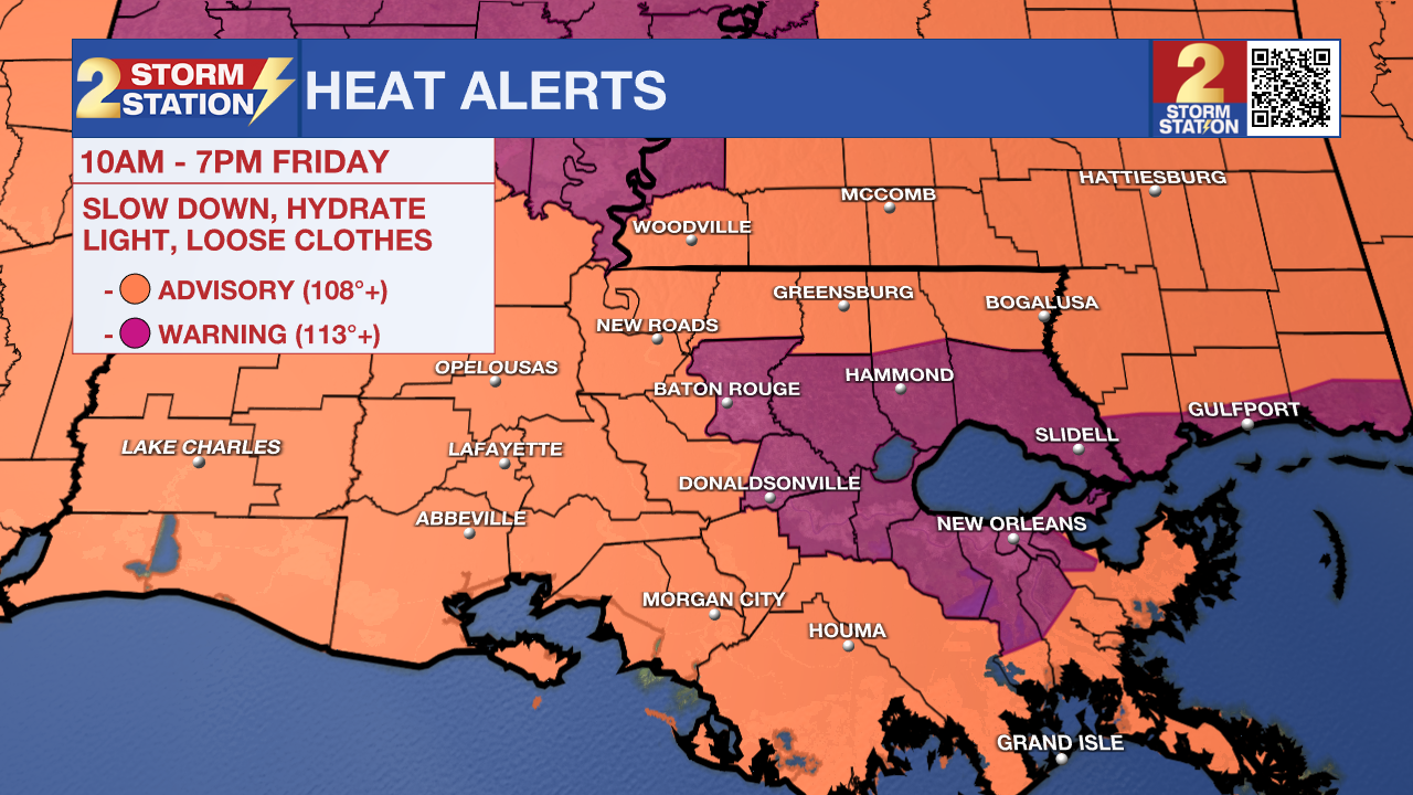
Today & Tonight: Friday is likely to be the hottest day of the week with a forecast high of 99° in Baton Rouge feeling as hot as +113° at times. The entire state is placed under heat alerts that will be in effect from 10am-7pm Friday. With these extreme temperatures, plenty of sunshine, and no relief from rain showers; it is advised to limit time outdoors all day long as some could develop heat illnesses. Overnight, warm and muggy conditions prevail as temperatures return near 80° with one or two spotty showers possible.
Up Next: The intense summertime heat continues into the first weekend of the month with mornings near 80 degrees warming quickly into the middle and upper-90's. More heat alerts will be possible as feels-like temperatures will stay well above 100° each afternoon. On Saturday, we will see a slight uptick in moisture as a very weak front approaches the state, this brings the best opportunity for afternoon and evening "cool-down" storms we've had all week. Isolated activity will be possible, but even then, over 50% of the forecast area is likely to miss out on a rain shower.
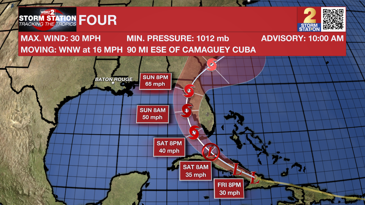
The Sunday – Monday forecast will greatly depend upon the behavior of a tropical system expected to be in the eastern Gulf of Mexico. While direct impacts to southern Louisiana appear unlikely, on the western side of this system there may be some drier and (relatively) cooler air pulled into the Capital Area. The sensible effects on local weather would be a slight drop in humidity and rain chances back to a minimum. More clarity and detail to the forecast is expected over the next 48 hours, so continue to check in with the Storm Station.
The Tropics: Potential Tropical Cyclone Four continues to move WNW across the Caribbean at 16mph, bringing showers and thunderstorms to Cuba on Friday as it gradually continues to strengthen. P.T.C. Four is forecast to become a Tropical Depression by Saturday morning and eventually become Tropical Storm Debby by the end of the weekend. The National Hurricane Center has issued Tropical Storm Watches and Warnings along the Florida coast ahead of this tropical system. The latest forecast track has the system making landfall over Florida during the day Sunday, bringing many threats including flooding rains. This track still has time to change so make sure to check back in regularly over the next 48 hours if heading anywhere along the gulf coast. Four does not pose any direct threats to the state of Louisiana at this time.
Trending News
Get the latest 7-day forecast and real time weather updates HERE.
Watch live news HERE.
– Emma Kate C.
The Storm Station is here for you, on every platform. Your weather updates can be found on News 2, wbrz.com, and the WBRZ WX App on your Apple or Android device. Follow WBRZ Weather on Facebook and Twitter for even more weather updates while you are on the go.
More News
