

Latest Weather Blog
Francine pulling away, conditions dramatically improving on Thursday
Francine is pulling away from southeast Louisiana, resulting in many improvements to the weather on Thursday. Into the weekend, the typical late summer pattern returns to the region.
Today & Tonight: Conditions will dramatically improve on Thursday. While there may be some lingering breezes, overall wind speeds will gradually diminish through the day. Look for winds in the ballpark of 5-15 mph with gusts to 20-25 mph during the morning and afternoon. Winds will calm even further into the evening. Clouds will be stubborn at first, but the sun should poke out during the afternoon. Any sunshine will help boost temperatures into the mid-80s around peak heating. Aside from a spotty shower or two, rain will be limited. Thursday night features a few clouds with overnight lows dipping into the upper-60s.
Up Next: Typical late-summertime conditions returns for the rest of the Storm Station 7-Day Forecast. Each day will bring a mixture of clouds and sun along with highs in the low-90s and plenty of mugginess. Rain chances also remain low each day.
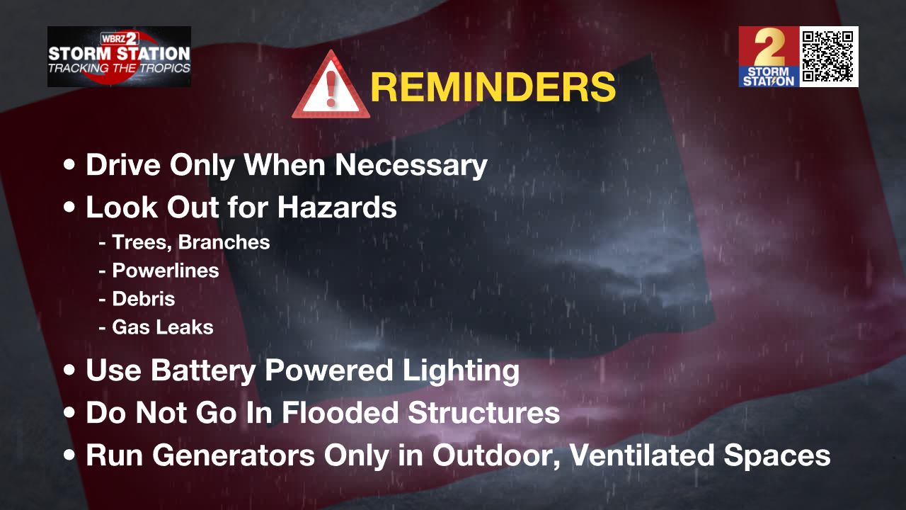
Safety After Francine: For those areas without power, please remember to operate generators safely in a well ventilated, outside location away from any air intake to your home. Additionally, avoid going into damaged or flooded buildings until you are sure they are free of gas leaks or dangerous wildlife.
Trending News
Click the icons below for resources for Francine:


The Tropics: Tropical Storm Francine continues to weaken as the storm continues to interact with land. The 1 a.m. advisory from the National Hurricane Center shifted the center of circulation to the east just north of Lake Pontchartrain. Francine will continue north through Thursday morning, eventually pushing into the I-20 corridor around daybreak as a weak tropical storm.

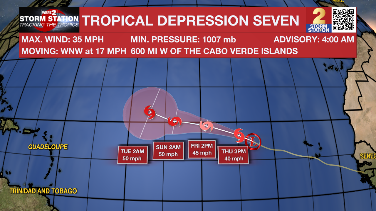
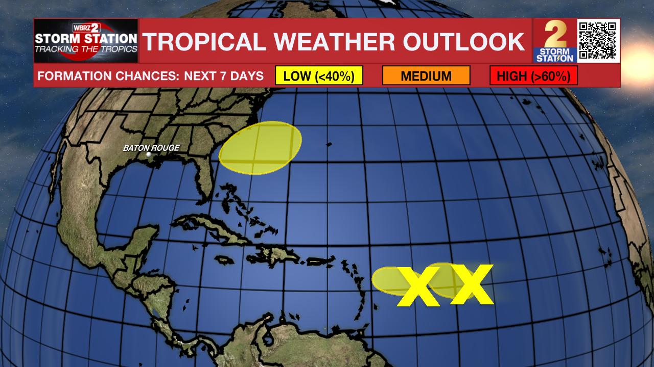
While Francine was bearing down on the Louisiana coast, a new tropical depression formed several hundred miles west of the Cabo Verde Islands. Tropical Depression Seven will move west through the tropical Atlantic, likely becoming Tropical Storm Gordon on Thursday. Fortunately, this storm will post no threats to Louisiana.
There are a few other tropical waves to watch also.
A small area of low pressure located several hundred miles to the east of the Leeward Islands is producing a few disorganized showers and thunderstorms. The proximity of dry air near the system is expected to limit additional organization over the next couple of days before environmental conditions become even less conducive for tropical development this weekend. This wave has very low odds of formation at this time.
Another weak area of low pressure located over the central tropical Atlantic is producing disorganized shower and thunderstorm activity. Development of this system is not likely as it moves westward through the central tropical Atlantic.
In a few days, a non-tropical area of low pressure could form along a remnant front which will be located a few hundred miles off the southeastern U.S. coastline. Thereafter, some subtropical or tropical development is possible during the early part of next week. Odds of formation are low for now, but if it does develop, it does not appear to be an issue for the Gulf Coast.
The Storm Station is here for you, tracking the tropics on every platform. Your weather updates can be found on News 2, wbrz.com, and the WBRZ WX App on your Apple or Android device. Follow WBRZ Weather on Facebook and Twitter for even more weather updates while you are on the go. You can also find tropical updates on our Hurricane Center HERE.
More News
