

Latest Weather Blog
FLOOD WATCH for Capital Area extended into the weekend
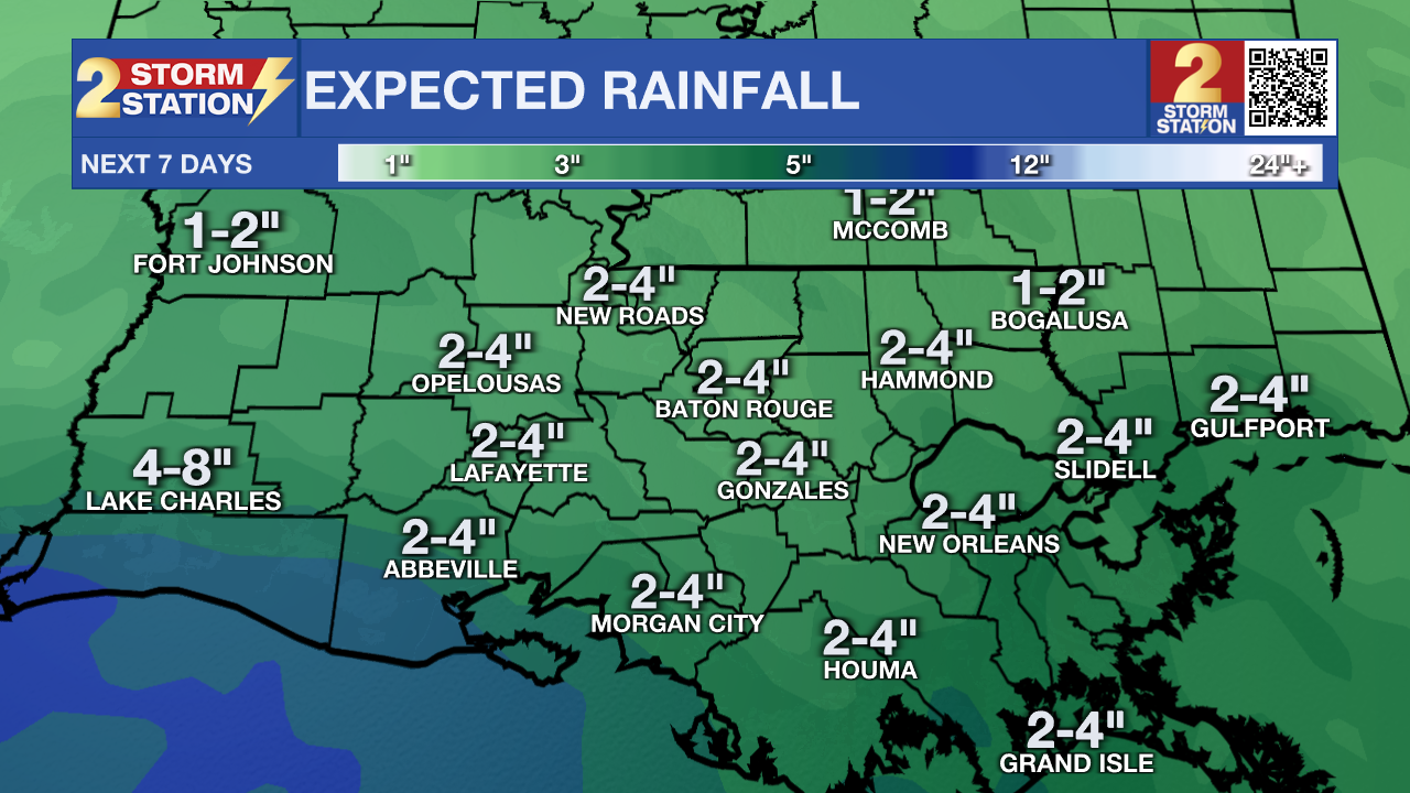
An area of low pressure in the northwestern Gulf of Mexico will not move much over the next couple of days. This will cause some more wet weather into the weekend.
A FLOOD WATCH is in effect for Baton Rouge and areas to the south and east through Saturday Evening. Excessive runoff may result in flooding of small creeks and other low-lying and flood-prone locations. Flooding may occur in poor drainage and urban areas. Storm drains and ditches may become clogged with debris. Monitor the forecast and be alert for possible Flood Warnings. Those living in areas prone to flooding should be prepared to take action should flooding develop.
Tonight & Tomorrow: Radar activity will start to die down as we head into the overnight hours. With a low pressure system close by, rain chances will not be completely eliminated. Expect lows in the middle 70's under mostly cloudy skies. We could once again get an early start to showers and storms Saturday. Overall, a washout is not expected, but throughout the course of the day, 80% of the viewing area will pick up measurable rainfall. Because of all the cloud cover and showers, highs will be limited to the middle 80's.
Up Next: By Sunday, the previously mentioned low pressure system will start to pull away, along with the very high moisture content. This will decrease our rain coverage to scattered in nature. Highs will be able to get to near 90 degrees. Moisture values will decrease even more for labor day, so only isolated pop-up storms are expected. The break in higher rain coverage will be short lived. Moisture will increase once again on Tuesday, and stay high through most of the week. This will once again increase the chances of rain.
Trending News
If you have plans for the Labor Day Weekend, nearby coastal communities will have similar weather to the Baton Rouge area. Be alert to darkening skies as it could signal thunderstorms. Lightning could chase you inside briefly, but do not expect any washouts. For LSU Football fans traveling to Las Vegas it will be downright hot. Afternoon temperatures on gameday will soar well into the 100s and postgame temperatures will still be in the 90s.
The Tropics: Three areas are currently being watched in the tropics. The first one, is pretty close to home.
An area of low pressure over the northwestern Gulf of Mexico is producing a large area of disorganized showers and thunderstorms along and just offshore the coasts of Texas and
Louisiana. This system is expected to meander near the coast through much of next week, and some slow development is possible if it remains offshore. Regardless of development, heavy rains could cause some flash flooding across portions of coastal Louisiana and the upper Texas coast during the next few days.
The next two areas are in the tropical Atlantic.
Showers and thunderstorms associated with a tropical wave over the central tropical Atlantic remain disorganized. Gradual development of this system is possible during the next few days, and a tropical depression could form some time next week while it moves westward, reaching the Lesser Antilles on Monday and continuing across the Caribbean Sea through the middle to latter part of the week.
Another tropical wave between the west coast of Africa and the Cabo Verde Islands is producing minimal shower and thunderstorm activity. Some slow development of this system is possible through late next week while it moves slowly to the west-northwest over the eastern and central tropical Atlantic.
Get the latest 7-day forecast and real time weather updates HERE.
Watch live news HERE.
– Balin
The Storm Station is here for you, on every platform. Your weather updates can be found on News 2, wbrz.com, and the WBRZ WX App on your Apple or Android device. Follow WBRZ Weather on Facebook and Twitter for even more weather updates while you are on the go.
More News
