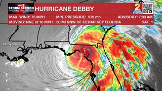
Hurricane Debby made landfall near Steinhatchee, Florida around 6:00 am CDT Monday morning as a Category 1 storm with peak winds around 80 mph. The storm will move inland on Monday and will weaken as it does so. Life-threatening storm surge, high winds, heavy rain, and tornadoes are possible in the region. This is the 9th year on record with 2 or more hurricane landfalls in the continental United States by August 5th (2020, 2005, 1959, 1936, 1934, 1916, 1909, 1886).
Debby will reach southern Georgia by Monday night and then slow its forward motion by midweek, stalling over the Southeast Coast. This will bring enormous amounts of rain to coastal Georgia, South Carolina, and North Carolina. Flooding is likely in those areas, even with Debby weakening to tropical storm status. No direct impacts are expected in Louisiana at this time.
This is a developing story. You can find the latest information on the storm in the most recent Storm Station Weather Blog found HERE.
The Storm Station is here for you, on every platform. Your weather updates can be found on News 2, wbrz.com, and the WBRZ WX App on your Apple or Android device. Follow WBRZ Weather on Facebook and Twitter for even more weather updates while you are on the go.
