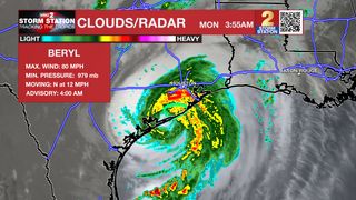
Hurricane Beryl made landfall near Matagorda, Texas shortly before 4 a.m. Monday. At landfall, the hurricane was at Category 1 strength with peak winds at 80 mph. The storm will continue to move inland on Monday and will weaken as it does so. Life-threatening storm surge, heavy rainfall, and tropical storm to hurricane-force winds have already been reported and will spread inland into east Texas Monday morning.
This is the third landfall in the storm’s history. Beryl made landfall on the island of Carriacou in Grenada as a high-end Category 4 hurricane on July 1st with peak winds at 150 mph. Afterward, the system intensified into a Category 5 storm as if continued west through the Caribbean Sea. The storm managed to weaken further as it brushed past Jamaica and the Cayman Islands. The storm then made landfall in the Yucatan Peninsula on Friday morning as a Category 2 hurricane with maximum sustained winds at 110 mph.
Beryl will become post-tropical by Tuesday and get swept away by an upper-level westerly wind. This will help bring additional moisture to southeast Louisiana, increasing both rain coverage and the heavy rain risk through midweek. This is a developing story. You can find the latest information on the storm in the most recent Storm Station Weather Blog found HERE.
The Storm Station is here for you, on every platform. Your weather updates can be found on News 2, wbrz.com, and the WBRZ WX App on your Apple or Android device. Follow WBRZ Weather on Facebook and Twitter for even more weather updates while you are on the go.