Surge of Tropical moisture brings widespread showers and a break from the heat to kickoff the workweek. Keep raingear handy.
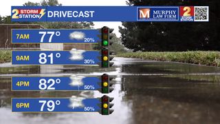
Today & Tonight: With plenty of moisture in the atmosphere, showers and storms will begin to develop across the region after sunrise Monday. Coverage of rain will likely peak this afternoon with a good chance that everyone in the Capital Region will see rain. While flooding is not a major concern with this round of storms, heavier downpours could result in localized flash flooding, especially for poor drainage and low-lying areas. Showers during the evening could make for a messy commute home. Temperatures, thanks to the rain, will only warm into the middle 80's with cooler temps left behind rain storms.
After sunset, rain coverage will drop drastically and mostly cloudy skies will remain. Overnight temperatures will reside in the 70's.
Up Next: The steady stream of tropical moisture will continue into Tuesday. Coverage, while still on the higher side (near 60%), will not be as high as today. That deep tropical moisture starts to pull away from us by the middle and end of the week. There will still be enough moisture for typical summertime pop up thunderstorms in the afternoon and evening. These will stay spotty, to isolated in nature. Because of the decreasing rain coverage, highs will rebound back to near the mid 90's on Thursday.
The Tropics: A large area of storms located over the Yucatan Peninsula will move over the southwestern Gulf of Mexico into next week. Conditions appear favorable for gradual development of this system. There is a high chance of tropical depression or storm formation by midweek. If the system were to reach tropical storm status (sustained winds 39+ mph), it would take the name Alberto.
The Storm Station believes that this system will remain well to the southwest of Louisiana. However, areas in northern Mexico and southern Texas should monitor the progress of the storm closely. Should the disturbance acquire tropical characteristics, find out first via the Storm Station mobile app.

Another area of low pressure is expected to form by midweek a few hundred miles northeast of the Bahamas. Conditions appear conducive for some development of the system as it drifts west, but overall odds appear low per the latest data. This disturbance would track west through Florida and hug the Gulf Coast. This is nothing to be concerned about as of now, but the Storm Station will keep a close eye on the system.
Get the latest 7-day forecast and real time weather updates HERE.
Watch live news HERE.
- Emma Kate Cowan
The Storm Station is here for you, on every platform. Your weather updates can be found on News 2, wbrz.com, and the WBRZ WX App on your Apple or Android device. Follow WBRZ Weather on Facebook and Twitter for even more weather updates while you are on the go.